27 March 2014
SITKINAK ISLAND, AK — Ever since the great magnitude 9.2 earthquake shook Alaska 50 years ago today, scientists have suspected that the quake’s rupture halted at the southwestern tip of Kodiak Island due to a natural barrier. However, recent research suggests some large quakes can punch through these obstacles, and have done so in the past, according to a new study accepted for publication in Geophysical Research Letters, a journal of the American Geophysical Union.
U.S. Geological Survey scientists and researchers from partner institutions working on Sitkinak Island, 15 miles southwest of Kodiak Island, unearthed geologic records from the last 1,000 years of at least three large subduction ruptures – sudden dislocations in which one crustal plate lurches beneath another – that broke through the western edge of the 1964 Alaska earthquake. Among the new findings is the first geologic evidence of the great 1788 Alaska earthquake and tsunami, a seismic event previously known only from historical writings from Russian settlements in the region at the time.
During the 1964 Alaska earthquake, a sudden slip on the subduction megathrust extended from near Kayak Island in the east to the southwestern tip of Kodiak Island in the west, resulting in widespread ground shaking and a damaging tsunami.
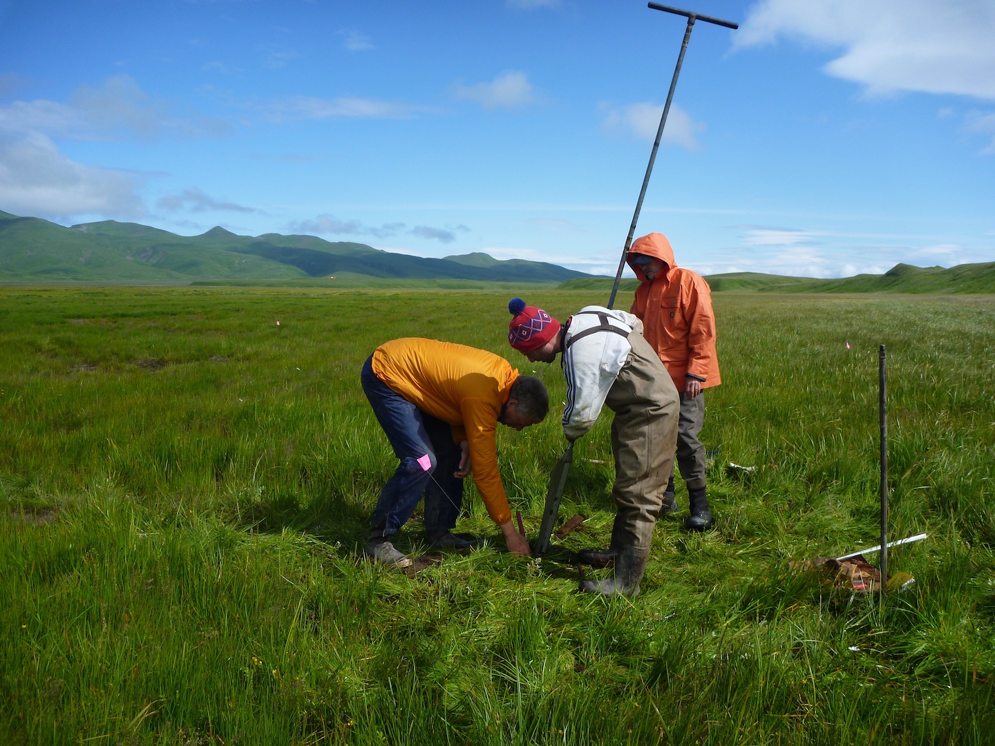
Geologists from the U.S. Geological Survey and Tufts University extract a hand-driven core on Sitkinak Island, Alaska. The cores contain peat with interbedded sand layers that record inundation of the coast by prehistoric tsunamis. A new study suggests that large earthquakes broke through the western edge of the 1964 Alaska earthquake.
Credit: USGS
To gather information on great earthquakes prior to 1964, the research team uncovered stratigraphic evidence of land-level change and tsunami inundation along the Alaska-Aleutian megathrust on Sitkinak Island. Hand-driven cores and tidal outcrops in a lagoon reveal five sharp changes in lithology and microfossils that record sudden upward and downward jerks during large earthquakes. Two of the changes correspond to the 1964 rupture and an earlier analog, while three sharp horizons mark ruptures that passed beneath Sitkinak Island, including the 1788 rupture.
“It’s been proposed that the edge of the 1964 rupture acts as a long-lived and stable barrier limiting the size of great earthquakes,” said Rich Briggs, lead author of the study and a USGS Research Geologist. “However, the geologic record suggests this isn’t the case, and that some, if not most large ruptures break through. Future studies will aim to determine the sizes of these boundary-busting ruptures. Understanding this problem is important because hazard models depend on an accurate understanding of the locations and sizes of prehistoric earthquakes,” Briggs added.
“The Sitkinak results demonstrate the crucial role that microfossils such as diatoms and foraminifera play in improving our understanding of great earthquake ruptures,” said Simon Engelhart, a University of Rhode Island researcher and study coauthor. “They were the smoking gun that indicated both coseismic uplift and subsidence have occurred and, therefore, that Sitkinak Island is not a persistent rupture boundary.”
Geologic evidence of a sudden uplift and an extensive sand sheet are consistent with Russian accounts of an earthquake and tsunami in 1788, but prior to this study no geologic evidence of this great event had been found.

Geologists drive a core into marsh sediment to document interbedded peat and silt that records sudden vertical land movements associated with megathrust fault slip during large earthquakes.
Credit: USGS
“The 1788 rupture had important consequences for Kodiak Island because it resulted in evacuation of the Russian outpost at Three Saints Bay (near Old Harbor) and resettlement at the present site of Kodiak (city),” said Briggs. “Historical documents and our geologic observations suggest the 1788 earthquake ruptured offshore Kodiak and extended toward the Shumagin Islands rather than toward Anchorage.”
Mapping prehistoric earthquakes in subduction zones requires a combination of approaches to indirectly capture evidence of massive undersea ruptures. Land-level changes and tsunami inundation—commonly recorded as raised or downdropped coasts and extensive sand sheets—can be revealed by mapping, coring, microfossil analysis, and a variety of dating techniques.
These findings have implications for hazard maps and tectonics studies, the study authors emphasized. An upcoming update of the USGS National Seismic Hazard Maps for Alaska will require a reevaluation of fault rupture histories.
“Understanding the ways faults have ruptured in the past is important because the paleoearthquake record gives us at least one set of scenarios to prepare for in the future,” said Briggs. “Geologic information joins other critical data, such as seismological and geophysical observations, in helping us generate useful hazard models.”
Notes for Journalists
Journalists and public information officers (PIOs) of educational and scientific institutions who have registered with AGU can download a PDF copy of this article by clicking on this link: http://onlinelibrary.wiley.com/doi/10.1002/2014GL059380/abstract
Or, you may order a copy of the final paper by emailing your request to Nanci Bompey at [email protected]. Please provide your name, the name of your publication, and your phone number.
Neither the paper nor this press release is under embargo.
“Uplift and subsidence reveal a non-persistent megathrust rupture boundary (Sitkinak Island, Alaska)”
Authors:
Richard W. Briggs: U.S. Geological Survey, Geologic Hazards Science Center, Golden, Colorado, USA;
Simon E. Engelhart: Dept. of Geosciences, University of Rhode Island, Kingston, Rhode Island, USA;
Alan R. Nelson: U.S. Geological Survey, Geologic Hazards Science Center, Golden, Colorado, USA;
Tina Dura: Dept. of Earth and Environmental Science, University of Pennsylvania, Philadelphia, Pennsylvania, USA;
Andrew C. Kemp: Dept. of Earth and Ocean Sciences, Tufts University, Lane Hall, Medford, Massachusetts, USA;
Peter J. Haeussler: U.S. Geological Survey, Alaska Science Center, Anchorage, Alaska, USA;
D. Reide Corbett: Dept. of Geological Sciences, East Carolina University, Greenville, North Carolina, USA;
Stephen J. Angster: U.S. Geological Survey, Geologic Hazards Science Center, Golden, Colorado, USA;
Lee-Ann Bradley: U.S. Geological Survey, Geologic Hazards Science Center, Golden, Colorado, USA.
Contact information for the authors:
Richard Briggs, +1 (303) 273-8465, [email protected]
Nanci Bompey
+1 (202) 777-7524
[email protected]
USGS Contact:
Heidi Koontz
+1 (303) 202-4763
[email protected]