9 October 2014
WASHINGTON, D.C. – One small “hot spot” in the U.S. Southwest is responsible for producing the largest concentration of the greenhouse gas methane seen over the United States – more than triple the standard ground-based estimate — according to a new study of satellite data.
Methane is very efficient at trapping heat in the atmosphere and, like carbon dioxide, it contributes to global warming. The hot spot, near the Four Corners intersection of Arizona, Colorado, New Mexico and Utah, covers only about 6,500 square kilometers (2,500 square miles), or half the size of Connecticut.
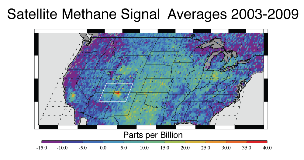
This map shows anomalous U.S. methane emissions (or how much the emissions differ from average background concentrations) for 2003 to 2009, as measured by the European Space Agency’s SCIAMACHY instrument. Purple and dark blue areas are below average. Pale blue and green areas are close to normal or slightly elevated. Yellows and red indicate higher-than-normal anomalies, with more intense colors showing higher concentrations. The Four Corners area – the area where Arizona, Colorado, New Mexico and Utah meet — is the only red spot on the map.
Credit:NASA/JPL-Caltech/University of Michigan
In each of the seven years studied from 2003-2009, the area released about 0.59 million metric tons (0.65 million U.S. tons) of methane into the atmosphere. This is almost 3.5 times the estimate for the same area in the European Union’s widely used Emissions Database for Global Atmospheric Research.
In the study published online today in Geophysical Research Letters, a journal of the American Geophysical Union, researchers used observations made by the European Space Agency’s Scanning Imaging Absorption Spectrometer for Atmospheric Chartography (SCIAMACHY) instrument. SCIAMACHY measured greenhouse gases from 2002 to 2012. The atmospheric hot spot persisted throughout the study period. A ground station in the Total Carbon Column Observing Network, operated by the Department of Energy’s Los Alamos National Laboratory, provided independent validation of the measurement.
To calculate the emissions rate that would be required to produce the observed concentration of methane in the air, the authors performed high-resolution regional simulations using a chemical transport model, which simulates how weather moves and changes airborne chemical compounds.
Research scientist Christian Frankenberg of NASA’s Jet Propulsion Laboratory (JPL) in Pasadena, California, first noticed the Four Corners signal years ago in SCIAMACHY data.
“We didn’t focus on it because we weren’t sure if it was a true signal or an instrument error,” Frankenberg said.
The study’s lead author, Eric Kort of the University of Michigan, Ann Arbor, noted the study period predates the widespread use of hydraulic fracturing, known as fracking, near the hot spot. This indicates the methane emissions should not be attributed to fracking but instead to leaks in natural gas production and processing equipment in New Mexico’s San Juan Basin, which is the most active coalbed methane production area in the country.
Natural gas is 95-98 percent methane. Methane is colorless and odorless, making leaks hard to detect without scientific instruments.
“The results are indicative that emissions from established fossil fuel harvesting techniques are greater than inventoried,” Kort said. “There’s been so much attention on high-volume hydraulic fracturing, but we need to consider the industry as a whole.”
Coalbed methane is gas that lines pores and cracks within coal. In underground coal mines, it is a deadly hazard that causes fatal explosions almost every year as it seeps out of the rock. After the U.S. energy crisis of the 1970s, techniques were invented to extract the methane from the coal and use it for fuel. By 2012, coalbed methane supplied about 8 percent of all natural gas in the United States.
Frankenberg noted that the study demonstrates the unique role space-based measurements can play in monitoring greenhouse gases.
“Satellite data cannot be as accurate as ground-based estimates, but from space, there are no hiding places,” Frankenberg said.
In March 2014 the Obama Administration announced a strategy to reduce methane emissions under its Climate Action Plan. The strategy includes improving the measurement and monitoring of methane emissions and assessing current methane emissions data.
###
The American Geophysical Union is dedicated to advancing the Earth and space sciences for the benefit of humanity through its scholarly publications, conferences, and outreach programs. AGU is a not-for-profit, professional, scientific organization representing more than 62,000 members in 144 countries. Join our conversation on Facebook, Twitter, YouTube, and other social media channels.
NASA monitors Earth’s vital signs from land, air and space with a fleet of satellites and ambitious airborne and ground-based observation campaigns. NASA develops new ways to observe and study Earth’s interconnected natural systems with long-term data records and computer analysis tools to better see how our planet is changing. The agency shares this unique knowledge with the global community and works with institutions in the United States and around the world that contribute to understanding and protecting our home planet.
For more information about NASA’s Earth science activities in 2014, visit: http://www.nasa.gov/earthrightnow
Notes for Journalists
Journalists and public information officers (PIOs) of educational and scientific institutions who have registered with AGU can download a PDF copy of this article by clicking on this link: http://onlinelibrary.wiley.com/doi/10.1002/2014GL061503/abstract
Or, you may order a copy of the final paper by emailing your request to Nanci Bompey at [email protected]. Please provide your name, the name of your publication, and your phone number.
Neither the paper nor this press release is under embargo.
“Four Corners: the largest US methane anomaly viewed from space”
Authors:
Eric A. Kort: Atmospheric, Oceanic and Space Sciences, University of Michigan, Ann Arbor, MI, USA;
Christian Frankenberg: Jet Propulsion Laboratory, California Institute of Technology, Pasadena, CA, USA;
Keeley R. Costigan: Earth and Environmental Sciences, Los Alamos National Lab, Los Alamos, NM, USA;
Rodica Lindenmaier: Earth and Environmental Sciences, Los Alamos National Lab, Los Alamos, NM, USA; and Atmospheric Chemistry and Global Change Division, now at Pacific Northwest National Laboratory, Richland, WA, USA;
Manvendra K. Dubey: Earth and Environmental Sciences, Los Alamos National Lab, Los Alamos, NM, USA;
Debra Wunch: California Institute of Technology, Pasadena, CA, USA.
Contact information for the authors:
Eric Kort: +1 (734) 763-8414,[email protected]
Christian Frankenberg: +1 (818) 354-1087, [email protected]
Nanci Bompey
+1 (202) 777-7524
[email protected]
NASA Headquarters Contact:
Steve Cole
+1 (202) 358-0918
[email protected]
NASA Jet Propulsion Laboratory Contact:
Alan Buis
+1 (818) 354-0474
[email protected]
University of Michigan Contact:
Nicole Casal Moore
+1 (734) 647-7087
[email protected]