Rising temperatures and risky development contribute to heightened exposure to earthquakes, flooding, tornadoes, hurricanes and wildfire
22 June 2021
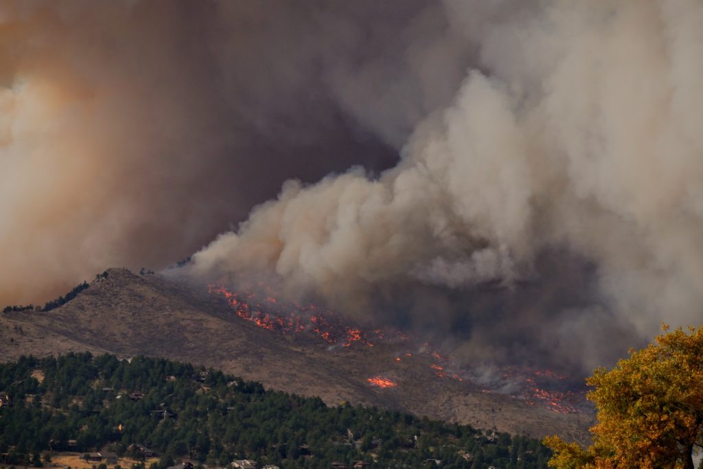
Smoke rises from Calwood Fire as it nears a neighborhood in Boulder County on October 17, 2020.
Credit: Malachi Brooks
AGU press contact:
Liza Lester, +1 (202) 777-7494, [email protected] (UTC-4 hours)
CIRES press contact
Brigitta Rongstad, [email protected] (UTC-6 hours)
Contact information for the researchers:
Virginia Iglesias, Earth Lab/CIRES/CU Boulder, [email protected] (UTC-6 hours)
WASHINGTON—More than half of the structures in the contiguous United States are exposed to potentially devastating natural hazards—such as floods, tornadoes and wildfires—according to a new study in the AGU journal Earth’s Future, which publishes interdisciplinary research on the past, present and future of our planet and its inhabitants.
Increasing temperatures and environmental changes contribute to this trend, and the research also shines the light on another culprit: the way humans develop open land, towns and cities.
“We know that climate change is increasing the risk of damage from some natural hazards,” said Virginia Iglesias, a research scientist with the University of Colorado Boulder Earth Lab and lead author of the paper. “But are losses also increasing because of the way that we are developing our cities, our towns?”
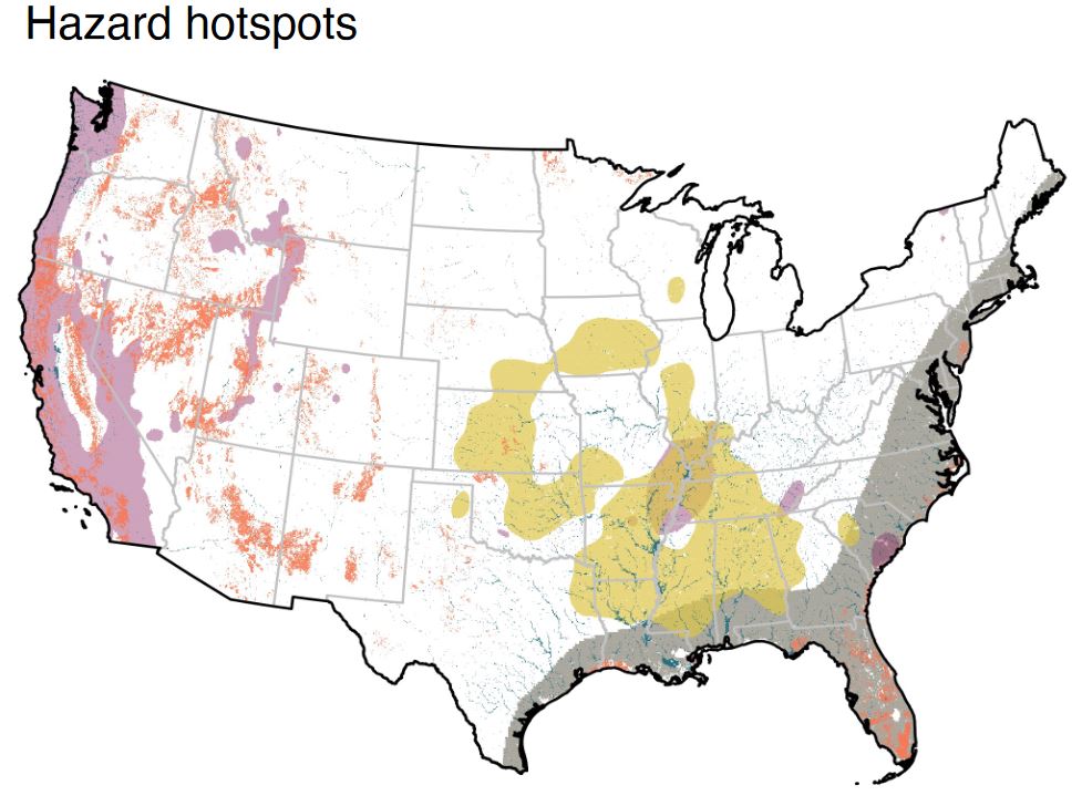
A new study finds more than half of the U.S. built environment is at risk of impact from natural hazards, largely due to development in hotspots of high exposure to earthquake (magenta), flood (cyan), hurricane (grey) tornado (yellow) and wildfire (orange). The probability or magnitude of natural events is assumed to be constant over the entire study period (1945-2015).
Credit: Inglesias et al. (2021) Earth’s Future https://doi.org/10.1029/2020EF001795
Yes, the new analysis found. To evaluate the impact of development on natural hazard risk, Iglesias and her colleagues built maps of earthquake, flood, hurricane, tornado and wildfire hazards and compared them to a unique dataset of historical land-use derived from Zillow’s housing and property database. The team identified natural hazard “hotspots” by mapping where the probability or magnitude of an individual natural hazard event fell in the top 10 percent.
“Since development patterns drive exposure and loss, more detailed mapping can improve national-scale risk assessments,” Iglesias said. “This study fills a gap by exploring changes in hazard exposure across the country, at fine resolution, for multiple hazards, and over long periods.”
The study shows that 57% of the structures in the contiguous United States are in natural hazard hotspots; these hotspots make up only about a third of the total land. About 1.5 million structures are in hotspots of two or more natural hazards. Despite a national slowdown in development over the last decade, the number of structures in natural hazard hotspots is still increasing, the authors found.
In some hotspots, people have built protections like levees and floodwalls, the authors noted in the new assessment. This becomes an interesting question for further research: can that infrastructure protect properties from hazardous events in the future?
The study also investigated regional development patterns that affect hazard risk. In hurricane and earthquake hotspots, for example, the primary driver for an increase in risk was the fact that people were adding buildings, homes, and other structures to already developed areas in cities and suburbs. In wildfire, flood, and tornado hotspots, it was the expansion of new buildings in rural areas and wildlands that increased risk of damage.
Iglesias and her colleagues suggest that local decision makers could use the methods innovated in this study to improve risk assessments in their purview and to better understand the socio-economic variables that might increase the risk exposure of neighborhoods or communities.
“Vulnerability matters. There’s evidence that natural disasters exacerbate socioeconomic inequality,” Iglesias said. “If we want to make decisions that effectively increase the ability of communities to cope with natural hazards, we need to know where vulnerable populations live, and the specific hazards they’re exposed to.”
###
AGU (www.agu.org) supports 130,000 enthusiasts to experts worldwide in Earth and space sciences. Through broad and inclusive partnerships, we advance discovery and solution science that accelerate knowledge and create solutions that are ethical, unbiased and respectful of communities and their values. Our programs include serving as a scholarly publisher, convening virtual and in-person events and providing career support. We live our values in everything we do, such as our net zero energy renovated building in Washington, D.C. and our Ethics and Equity Center, which fosters a diverse and inclusive geoscience community to ensure responsible conduct.
Notes for Journalists:
This research study is open access. Download a PDF copy of the paper here. Neither the paper nor this press release is under embargo.
Paper title:
“Risky development: Increasing exposure to natural hazards in the United States”
Authors:
- Virginia Iglesias, Anna E. Braswell, Matthew W. Rossi, Maxwell B. Joseph: Earth Lab, Cooperative Institute for Research in Environmental Sciences (CIRES), University of Colorado, Boulder, Colorado, USA;
- Caitlin McShane: Department of Geography, University of Colorado, Boulder, Colorado, USA;
- Megan Cattau: Human‐ Environment Systems, Boise State University, Boise, Idaho, USA;
- Michael J. Koontz, Joe McGlinchy, R. Chelsea Nagy: Earth Lab, Cooperative Institute for Research in Environmental Sciences (CIRES), University of Colorado, Boulder, Colorado, USA;
- Jennifer Balch: Earth Lab, Cooperative Institute for Research in Environmental Sciences (CIRES), and Department of Geography, University of Colorado, Boulder, Colorado, USA;
- Stefan Leyk: Earth Lab, Cooperative Institute for Research in Environmental Sciences (CIRES), University of Colorado, Boulder, Colorado, USA;
- William R. Travis: Earth Lab, Cooperative Institute for Research in Environmental Sciences (CIRES), and Department of Geography, University of Colorado, Boulder, Colorado, USA.
CIRES release