New research highlights the risk of strong earthquakes in the Eastern Mediterranean
10 May 2021
AGU press contact:
Nanci Bompey, +1 (202) 777-7524, [email protected]
GFZ German Research Centre for Geosciences press contact:
Josef Zens, +49 331 288-1040, [email protected]
Contact information for the researchers:
Richard Ott, GFZ German Research Centre for Geosciences, +49 331 288-28601, [email protected]
WASHINGTON— On the morning of 21 July, AD 365, the Eastern Mediterranean was shaken by an earthquake that is generally believed to be the strongest recorded earthquake in the Mediterranean. It probably originated around Crete, Greece, and was followed by a tsunami that hit the Mediterranean coastlines causing many deaths. In Alexandria, tsunami devastation was so severe that the day of the event was commemorated as the “day of horror” for centuries after the event.

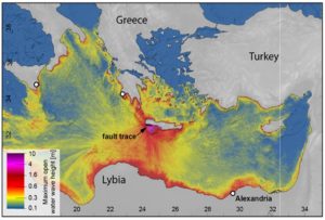
This map shows the modeled wave heights of the tsunamis on the coasts in the eastern Mediterranean Sea, which were triggered by the earthquake on July 21, 365.
Credit: Richard Ott
The earthquake was strong enough to lift parts of Crete by several meters. This upheaval of the island left behind fossil shorelines, which Richard Ott, a scientist at the GFZ German Research Centre for Geosciences, and colleagues studied to reconstruct this the event.
The new study published in AGU Advances, which publishes high-impact, open-access research and commentary across the Earth and space sciences, used radiocarbon dating to understand when and how much shorelines on Crete were uplifted and utilized this information to model the source of the earthquakes and tsunamis.
Understanding which fault, a fracture in the Earth’s crust, the earthquake originated on is important to understanding the hazard of earthquakes and tsunamis in the Mediterranean.
Uplift of Crete and fossil shorelines

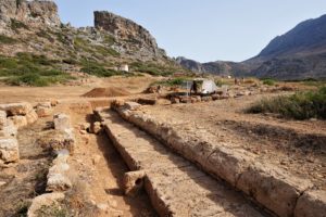
A hint to the enormous forces that uplifted Crete can be found at the ruins of the ancient harbor town in Phalasarna in western Crete.
Credit: Richard Ott
A hint to the enormous forces that uplifted Crete can be found at the ruins of the ancient harbor town in Phalasarna in, western Crete. People visiting today can explore a beautiful, perfectly preserved wharf from Roman times. However, this wharf is now several hundred meters away from the sea and approximately seven meters above sea level.
There is another peculiar phenomenon in western Crete. Something that looks like a notch is recognizable in the coastal cliffs running parallel to the sea. This notch is what scientists call a fossil shoreline and marks where sea level used to be in the past. It is nowadays found up to 9 meters above sea level in western Crete.
When did the uplift occur?

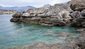
An ancient earthquake was strong enough to lift parts of Crete by several meters. This upheaval of the island left behind fossil shorelines, which Richard Ott, a scientist at the GFZ German Research Centre for Geosciences, and colleagues studied to reconstruct this the event.
Credit: Richard Ott
In the new study, Ott and his colleagues refined the dating of this fossil shoreline and compared the data from many samples to historical records of earthquakes by ancient writers.
Radiocarbon analysis of fossils below this fossil shoreline of western Crete can helped to determine when the island’s upheaval occurred. Ott and his team collected fossil samples of vermetids (Dendropoma sp.) and corals (Balanophyllia sp.) from at and below the Krios paleoshoreline at eight different sites in western Crete. Shells and skeletons from these dead marine organisms mark when the uplift occurred because they died when the earthquake lifted them above sea level.
The team of scientists found the fossil shoreline was probably not uplifted in one big earthquake, but rather by a series of strong earthquakes around the island of Crete in the first centuries AD. The new finding is consistent with archaeological investigations suggesting the ancient harbor in Phalasarna was already abandoned after an earthquake in AD 66.

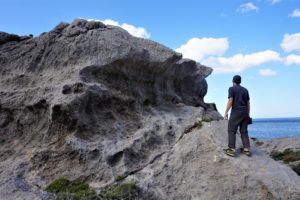
A notch is recognizable in the coastal cliffs in western Crete running parallel to the sea. This notch is what scientists call a fossil shoreline and marks where sea level used to be in the past.
Credit: Richard Ott
In contrast to previous studies, the team found normal faults likely are responsible for this earthquake sequence. Normal faults are a certain type of fracture in the Earth’s crust that occur when Earth’s crust is being pulled apart or extended. The scientists model the propagation of tsunamis from earthquakes on these normal faults and find their new type of model can well explain the tsunami report from Alexandria by Ammianus Marcellinus, a historic writer.
These findings suggest earthquakes on such normal faults are probably a common tsunami trigger in the Mediterranean. The authors estimate the size of the earthquake in AD 365 was below Mw 8, which is lower than previous Mw 8.3-8.5 estimates. However, the study highlights that there is a risk of strong earthquakes in the Eastern Mediterranean, and locals and tourists should be educated on how to act in the event of a tsunami.
###
AGU (www.agu.org) supports 130,000 enthusiasts to experts worldwide in Earth and space sciences. Through broad and inclusive partnerships, we advance discovery and solution science that accelerate knowledge and create solutions that are ethical, unbiased and respectful of communities and their values. Our programs include serving as a scholarly publisher, convening virtual and in-person events and providing career support. We live our values in everything we do, such as our net zero energy renovated building in Washington, D.C. and our Ethics and Equity Center, which fosters a diverse and inclusive geoscience community to ensure responsible conduct.
Notes for Journalists:
This research study is freely available. Download a PDF copy of the paper here. Neither the paper nor this press release is under embargo.
Paper title: “Reassessing Eastern Mediterranean tectonics and earthquake hazard from the AD365 earthquake
Authors:
- Richard F. Ott: ETH Zurich, Zurich, Switzerland, and German Centre for Geoscience Research, Potsdam, Germany;
- Karl W. Wegmann: North Carolina State University, Raleigh, NC, U.S.A.;
- Sean F. Gallen: Colorado State University, Fort Collins, CO, U.S.A.;
- Frank J. Pazzaglia: Lehigh University. Bethlehem, PA, U.S.A.;
- Mark T. Brandon: Yale University, New Haven, CT, U.S.A.;
- Kosuke Ueda: ETH Zurich, Zurich, Switzerland;
- Charalampos Fassoulas: Natural History Museum of Crete, University of Crete, Heraklion, Greece.