1 October 2020
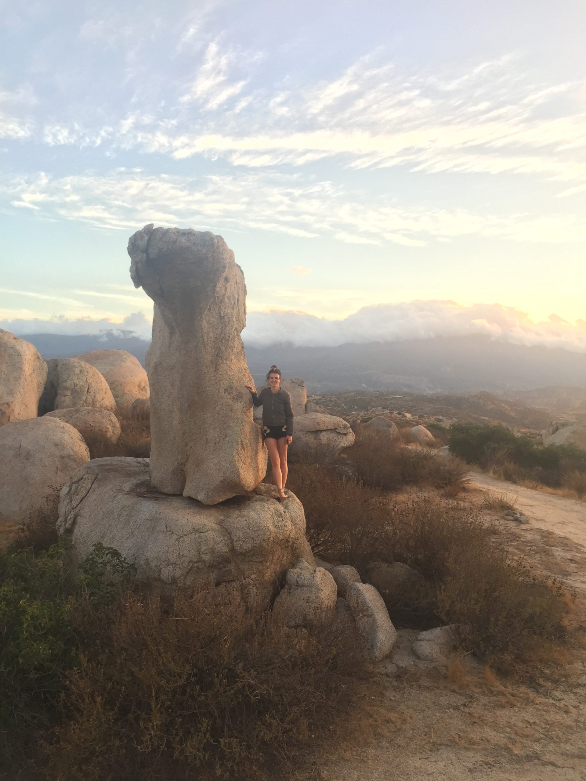
Researcher Anna Rood stands next to a tall, slender, precariously balanced rock in Southern California. Cosmogenic surface exposure dating samples have been collected to determine its age, and a 3D model has been made to determine its probability of toppling due to earthquake ground shaking.
Credit: Anna Rood & Dylan Rood, Imperial College London
AGU press contact:
Liza Lester, +1 (202) 777-7396, [email protected]
Imperial College London press contact:
Caroline Brogan, +44(0)20 7594 3415, [email protected]
Contact information for the researchers:
Anna Rood, [email protected], and Dylan Rood, [email protected], Imperial College London
WASHINGTON—Naturally formed balancing boulders could be used to help scientists to forecast large earthquakes more precisely, according to a new study in the journal AGU Advances.
Many balanced rocks have survived earthquake shaking over thousands of years, setting an upper limit for shaking strong enough to topple them. By tapping into ancient geological data locked within Californian precariously balanced rocks, or PBRs, the new study narrowed the precision of hazard estimates for large earthquakes by up to 49%.
The new study also found the delicate formations can be preserved in the landscape for twice as long as previously thought.
Slender boulders balanced precariously on rocky pedestals, like the Brimham Rocks in Yorkshire, or Chiricahua National Monument in Arizona, form as blocks preserved on cliffs, or when softer rocks erode and leave the harder rocks behind. They can also form when landslides or retreating glaciers deposit them in strange positions.
Earthquake hazard models estimate the likelihood of future earthquakes in a given location. They help engineers decide where bridges, dams, and buildings should be built and how robust they should be – as well as informing earthquake insurance prices in high-risk areas.
“This new approach could help us work out which areas are most likely to experience a major earthquake. PBRs act like inverse seismometers by capturing regional seismic history that we weren’t around to see, and tell us the upper limit of past earthquake shakes simply by not toppling. By tapping into this, we provide uniquely valuable data on the rates of rare, large-magnitude earthquakes,” said Anna Rood, a researcher in Civil and Environmental Engineering at Imperial College London and the lead author of the new study.
Current earthquake hazard estimates rely largely on observations like proximity to fault lines and how seismically active a region has been in the past. However, estimates for rarer earthquakes that have occurred over periods of 10,000 to 1,000,000 years are extremely uncertain due to the lack of seismic data spanning those timescales and subsequent reliance on rocky assumptions.
By counting rare cosmic ray-generated atoms in PBRs and digitally modelling PBR-earthquake interactions, Imperial researchers have created a new method of earthquake hazard validation that could be built into existing models to finetune their precision.
Rock clocks
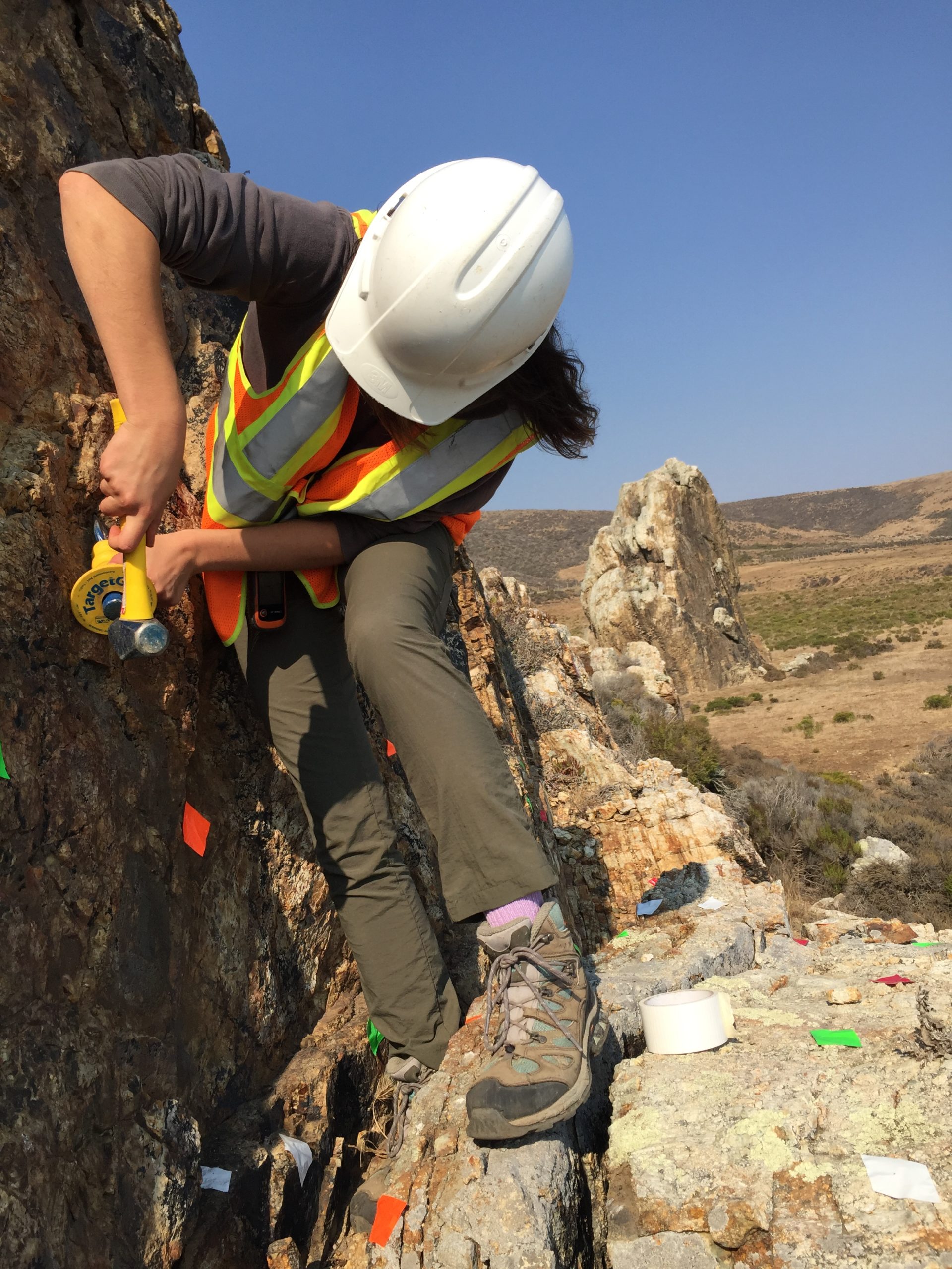
Anna Rood collecting a sample for cosmogenic surface exposure dating, which was used to deduce the fragility age of the PBR beneath her front foot.
Credit: Anna Rood & Dylan Rood, Imperial College London
To tap into the seismology of the past, the researchers set out to determine the fragility (likelihood of toppling due to ground shaking) and age of PBRs at a site near to the Diablo Canyon Nuclear Power Plant in coastal California.
They used a technique called cosmogenic surface exposure dating – counting the number of rare beryllium atoms formed within rocks by long-term exposure to cosmic rays – to determine how long PBRs had existed in their current formation.
They then used 3D modelling software to digitally recreate the PBRs and calculate how much earthquake ground shaking they could withstand before toppling.
Both the age and fragility of the PBRs were then compared with current hazard estimates to help boost their certainty.
They found that combining their calculations with existing models reduced the uncertainty of earthquake hazard estimates at the site by 49 per cent, and, by removing the ‘worst-case-scenario’ estimates, reduced the average size of earthquakes estimated to happen once every 10,000 years by 27 per cent.
They conclude that this new method reduces the amount of assumptions, and therefore the uncertainty, used in estimating and extrapolating historic earthquake data for estimates of future risk.
“We’re teetering on the edge of a breakthrough in the science of earthquake forecasting. Our ‘rock clock’ techniques have the potential to save huge costs in seismic engineering, and we see them being used broadly to test and update site-specific hazard estimates for earthquake-prone areas — specifically in coastal regions where the controlling seismic sources are offshore faults whose movements are inherently more difficult to investigate,” said co-author Dylan Rood, a researcher in Earth Science and Engineering at Imperial College London.
The team are now using their techniques to validate hazard estimates for southern California – one of the most hazardous and densely populated regions of the United States.
“We’re now looking at PBRs near major earthquake faults like the San Andreas fault near Los Angeles. We’re also looking at how to pinpoint which data — whether it be fault slip rates or choice of ground shaking equations — are skewing the results in the original hazard models. This way we can improve scientists’ understanding of big earthquakes even more,” said Anna Rood.
This study was funded by Pacific Gas and Electric Company (PG&E), National Science Foundation (NSF), British Society for Geomorphology, and Australia’s Nuclear Science and Technology Organisation (ANSTO).
AGU (www.agu.org) supports 130,000 enthusiasts to experts worldwide in Earth and space sciences. Through broad and inclusive partnerships, we advance discovery and solution science that accelerate knowledge and create solutions that are ethical, unbiased and respectful of communities and their values. Our programs include serving as a scholarly publisher, convening virtual and in-person events and providing career support. We live our values in everything we do, such as our net zero energy renovated building in Washington, D.C. and our Ethics and Equity Center, which fosters a diverse and inclusive geoscience community to ensure responsible conduct.
*****
Notes for Journalists
This research study is open access. Download a PDF copy of the paper here. Additional photos are available from Imperial College London. Neither the paper nor this press release is under embargo.
Paper title:
“Earthquake Hazard Uncertainties Improved Using Precariously Balanced Rocks”
Authors:
A. H. Rood, Department of Civil and Environmental Engineering, Imperial College London, London, UK
D. H. Rood, Department of Earth Science and Engineering, Imperial College London, London, UK
M. W. Stirling, Department of Geology, University of Otago, Dunedin, New Zealand
C. M. Madugo, Geosciences Department, Pacific Gas and Electric Company, San Francisco, CA, USA
N. A. Abrahamson, Pacific Earthquake Engineering Research Center, University of California, Berkeley, CA, USA
K. M. Wilcken, Australian Nuclear Science and Technology Organisation (ANSTO), Lucas Heights, New South Wales, Australia
T. Gonzalez, Earth Consultants International Inc, Santa Ana, CA, USA
A. Kottke, Geosciences Department, Pacific Gas and Electric Company, San Francisco, CA, USA
A. C. Whittaker, Department of Earth Science and Engineering, Imperial College London, London, UK
W. D. Page, Geosciences Department, Pacific Gas and Electric Company, San Francisco, CA, USA
P. J. Stafford, Department of Civil and Environmental Engineering, Imperial College London, London, UK
***