29 March 2011
WASHINGTON—A new study has revealed widespread reductions in the greenness of Amazon forests caused by the last year’s record-breaking drought.
“The greenness levels of Amazonian vegetation — a measure of its health — decreased dramatically over an area more than three and one-half times the size of Texas and did not recover to normal levels, even after the drought ended in late October 2010,” says Liang Xu of Boston University and the study’s lead author.
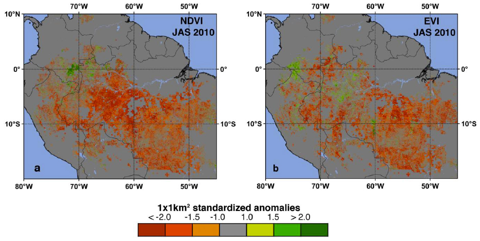
Red and orange identify areas where satellite measurements indicated reduced greenness of the Amazon forest during the 2010 drought. (Green patches are areas of enhanced greenness.) The maps differ only in the method used for determining vegetation greenness from optical data.
The drought sensitivity of Amazon rainforests is a subject of intense study. Computer models predict that in a changing climate with warmer temperatures and altered rainfall patterns, the ensuing moisture stress could cause some of the rainforests to be replaced by grasslands or woody savannas. This would release the carbon stored in the rotting wood into the atmosphere, and could accelerate global warming. The United Nations’ Intergovernmental Panel on Climate Change has warned similar droughts could be more frequent in the Amazon region in the future.
The comprehensive study was prepared by an international team of scientists using more than a decade’s worth of satellite data from NASA’s Moderate Resolution Imaging Spectroradiometer (MODIS) and Tropical Rainfall Measuring Mission (TRMM).
Analysis of these data produced detailed maps of vegetation greenness declines from the 2010 drought. The study has been accepted for publication in Geophysical Research Letters, a journal of the American Geophysical Union.
The authors first developed maps of drought-affected areas using thresholds of below-average rainfall as a guide. Next, they identified affected vegetation using two different greenness indexes as surrogates for green leaf area and physiological functioning.
The maps show the 2010 drought reduced the greenness of approximately 2.5 million square kilometers (965,000 square miles) of vegetation in the Amazon — more than four times the area affected by the last severe drought in 2005.
“The MODIS vegetation greenness data suggest a more widespread, severe and long-lasting impact to Amazonian vegetation than what can be inferred based solely on rainfall data,” says Arindam Samanta, a co-lead author from Atmospheric and Environmental Research Inc. in Lexington, Mass.
The severity of the 2010 drought was also seen in records of water levels in rivers across the Amazon basin, including the Rio Negro which represents rainfall levels over the entire western Amazon. Water levels started to fall in August 2010, reaching record low levels in late October. Water levels only began to rise with the arrival of rains later that winter.
“Last year was the driest year on record based on 109 years of Rio Negro water level data at the Manaus harbor. For comparison, the lowest level during the so-called once-in-a-century drought in 2005, was only eighth lowest,” said Marcos Costa, coauthor from the Federal University in Vicosa, Brazil.
As anecdotal reports of a severe drought began to appear in the news media during the summer of 2010, the authors started near-real time processing of massive amounts of satellite data. They used a new capability, the NASA Earth Exchange (NEX), built for the NASA Advanced Supercomputer facility at the agency’s Ames Research Center in Moffett Field, Calif. NEX is a collaborative supercomputing environment that brings together data, models and computing resources.
With NEX, the study’s authors quickly obtained a large-scale view of the impact of the drought on the Amazon forests and were able to complete the analysis by January 2011. Similar reports about the impact of the 2005 drought were published about two years after the fact.
“Timely monitoring of our planet’s vegetation with satellites is critical, and with NEX it can be done efficiently to deliver near-real time information, as this study demonstrates,” said study coauthor Ramakrishna Nemani, a research scientist at Ames. An article about the NEX project appears in today’s issue of Eos, the weekly newspaper of the American Geophysical Union.
Joint Release
AGU Contact:
Peter Weiss, +1 202 777 7507, [email protected]
NASA Contact:
Steve Cole, +1 202 358 0918, [email protected]
Boston University Contact:
Patrick Farrell, +1 617 358 1185, [email protected]
As of the date of this press release, the paper by Xu et al. is still “in press” (i.e. not yet published). Journalists and public information officers (PIOs) of educational and scientific institutions who have registered with AGU candownload a PDF copy of this paper.
The Eos article by Nemani et al. is also available online.
Or, you may order a copy of the paper by emailing your request to Peter Weiss at [email protected]. Please provide your name, the name of your publication, and your phone number. Neither the paper nor this press release are under embargo.
“Widespread Decline in Greenness of Amazonian Vegetation Due to the 2010 Drought”
Liang Xu and Ranga B. MyneniDepartment of Geography and Environment, Boston University, Boston, Massachusetts, USA;Arindam SamantaAtmospheric and Environmental Research Inc., Lexington, Massachusetts, USA;Marcos H. CostaFederal University of Viçosa (UFV), Viçosa, Brazil;Sangram GangulyBay Area Environmental Research Institute, NASA Ames Research Center, Moffett Field, California, USA;Ramakrishna R. NemaniBiospheric Science Branch, NASA Ames Research Center, Moffett Field, California, USA.
Liang Xu:[email protected], (617) 510-6583
Arindam Samanta: [email protected], (617) 852-5256
Marcos Costa:[email protected], +55-31-3899-1899
Rama Nemani:[email protected], (650) 919-4270
Ranga Myneni: [email protected], (617) 470-7065