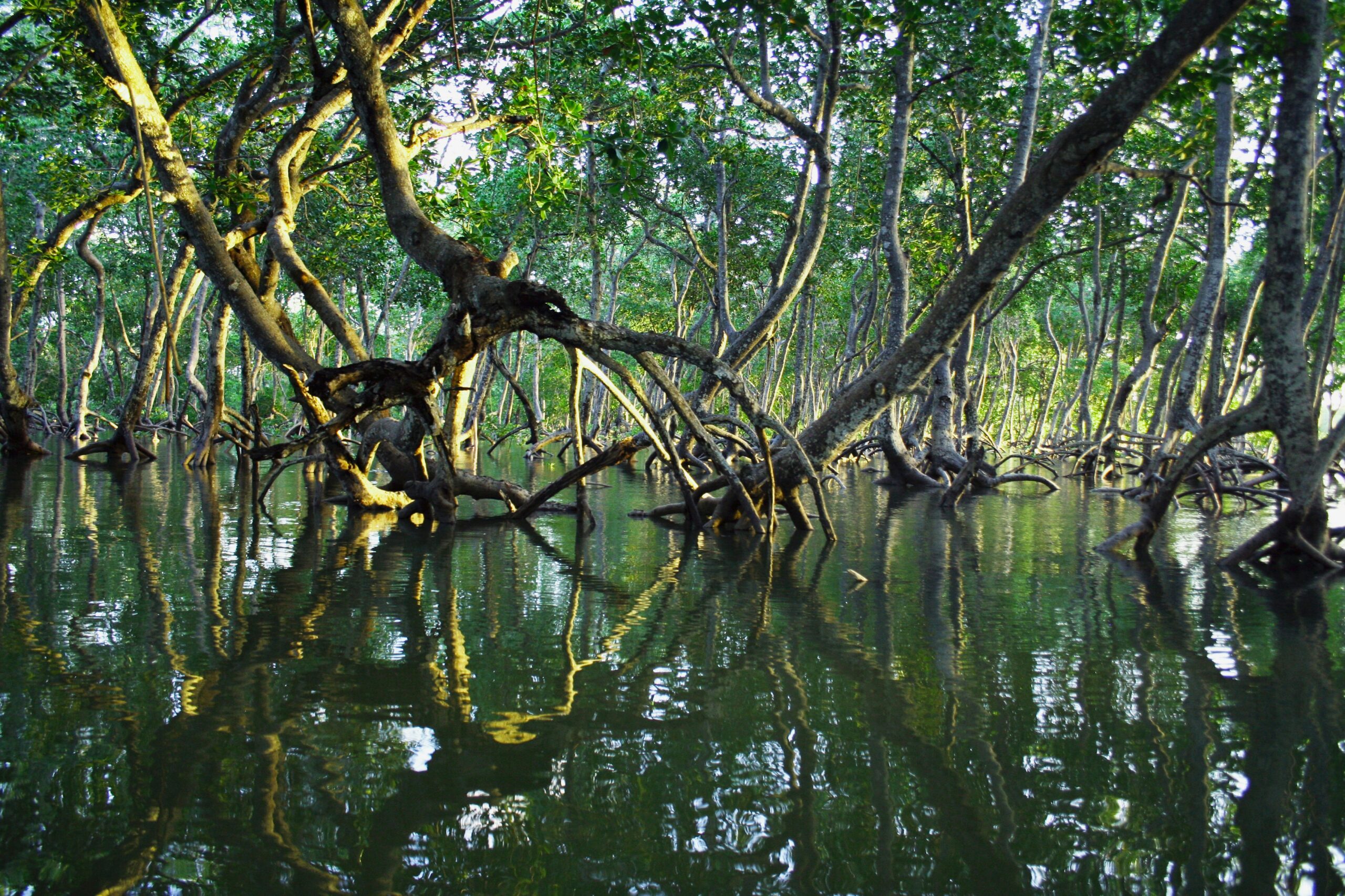
4/2/2026: As Earth’s climate warms, when it rains, it pours

Two people on a moped in a flooded city street during a downpour at night

As climate change continues, more regions are receiving a greater share of their total rainfall through extreme rain events. Among other impacts, this can stress food and economic security in areas that rely on rainfed agriculture. Credit: qimono, Pixabay

AGU News 

AGU 2026 Journalism Awards call for nominations 

AGU is now accepting nominations for its 2026 Journalism Awards, which honor outstanding reporting on the Earth and space sciences published in 2025. Nominate your or your peers’ best work by Sunday, 19 April 2026 at 11:59 p.m. ET. [press release and submission links] 

Attend the 2026 Astrobiology Science Conference in Madison, Wisconsin, 17-22 May
Reporters and press officers interested in press registration should email AGU Media Relations at [email protected]. Please include a link to a byline, masthead or a staff page listing your name and position. Freelancers should provide a link to a portfolio or links to at least three bylined science news stories published in the last 12 months. [AbSciCon home] [program] 

Lunar research roundup 

With Artemis II’s crew set to begin their outbound lunar transit tonight, check out the latest research on Earth’s Moon from AGU journals: 

  • Apollo Next Generation Sample Analysis cracks open “new” 50-year-old lunar samples from NASA’s collection [JGR Planets special collection][introduction] 
  • Looking for a sunny spot near cold pits of darkness: where to land on the south pole of the Moon [JGR Planets study] 
  • How to bring a snowball souvenir back from space: the challenge of icy sample return begins with Artemis [Geophysical Research Letters study 
  • Day-night temperatures for scientific sightseeing locations on the Moon [Earth and Space Science study] 
  • Astronauts could listen for moonquakes with fiber optic cables [Earth and Space Science study] 
  • Lunar spacecraft exhaust could obscure clues to origins of life [press release][JGR Planets study] 

Featured Research 

As the climate warms, more of Earth’s rainfall arrives via extreme rain events
Should Earth warm by four degrees Celsius from preindustrial levels, much its land area could see a 15% to 20% increase in the fraction of its rain that comes from extreme rain events. The African Sahel, the Amazon, Southeast Asia, and northern Australia would rank among the most affected regions, according to new climate model projections. More than half of global croplands could suffer as a result, and low-income countries reliant on rainfed agriculture would be especially hard-pressed to maintain food security and economic stability. The finding highlights the need to limit warming to below 2 degrees Celsius, the researchers wrote, especially as many regions are already seeing extreme rain dominate their total annual rainfall even faster than models predict. [Water Resources Researchstudy] 

Meteorites from Earth or Mars could theoretically seed life on the clouds of Venus 
Chunks of rock knocked loose from Earth or Mars (if life existed there) could, in theory, fly through space and deliver life to the clouds of Venus, according to recent model simulations. Small amounts of the rock could survive entering Venus’ atmosphere while still carrying living cells, scattering in fragments tiny enough to float in the clouds. Researchers estimate this process could theoretically send about 100 cells to Venus’s clouds every Earth-year. What happens after that remains unclear: although too little water exists in the Venusian sky to support Earthly life, the pressures and temperatures there resemble those on Earth’s surface, making it a place of interest to scientists studying the possibility of extraterrestrial life. [JGR Planetsstudy] 

Global wheat yields take a hit from rising extreme heat-drought combos 
Simultaneous extreme heat and drought, on the rise due to human-driven climate change, is hurting global wheat yields. For over 70% of the world’s wheat-growing area, when these hot-dry combos persist for more than 10% of the growing season, yields drop by over 6%, on average. Canada, Australia, and Central Asia suffer the most severe impacts, while heavily irrigated regions like China and India are less affected. The findings come from a recent study including analysis of meteorological and soil data from 1981 to 2020. Heat and drought can hinder wheat production more in tandem than when they occur separately, the researchers wrote. [Earth’s Futurestudy]  

Air pollution disproportionately affects Cape Town’s vulnerable communities
Over 40% of the population of Cape Town, South Africa, lives in areas at high or very high risk for air pollution, mostly in informal settlements and historically disadvantaged neighborhoods. Researchers arrived at the result after comparing social vulnerability data with satellite data on air quality, an approach that allowed them to consider areas lacking traditional air quality monitors. The finding highlights the need to consider social factors and prioritize high-risk areas when addressing air pollution, the team wrote: improving housing and healthcare access in socially vulnerable communities, for instance, could mitigate adverse impacts. [GeoHealthstudy]  

Asia’s heat-flood combo of 2022 unlikely without human-driven climate change
An extreme weather combination that hit Asia in the summer of 2022, consisting of simultaneous floods in Pakistan and heatwaves in the Yangtze River Basin, likely wouldn’t have happened without the influence of human-driven climate change. Researchers compared the atmospheric conditions of 2022 against those during a similar combined weather event in 2010 that inflicted significant socioeconomic impacts in the same regions. They found that the 2022 event was essentially a version of its 2010 counterpart, but amplified by warming. In a future scenario of high greenhouse gas emissions, they estimated, events like that of 2022 could become 57 to 326 times more probable by the last 30 years of this century. [Water Resources Researchstudy]  

What’s under the water matters
The fate of barrier islands in presence of sea level rise depends on their underwater shape. [Eos editors’ highlight][JGR Earth Surface study] 

Subscribe or update your subscription preferences 

3/26/2026: Super-wet winters may recharge western U.S. mountains’ groundwater

A massive, snowy mountain at sunset, wreathed in clouds and towering over smaller, tree-covered mountains below

Mount Rainier in Washington state. The Sierra Nevada and Cascade mountain ranges in the western U.S. are losing groundwater, but new research suggests short, extreme bursts of winter precipitation may help them recover groundwater lost during long dry spells. Credit: U.S. National Park Service, Wikimedia Commons

AGU News 

Earth’s Future expands scope
AGU’s popular journal for interdisciplinary research on the past, present and future of our planet and its inhabitants is adding three new thematic areas: climate impacts, communities and resilience, and sustainable resource systems. Learn more about the research directions these topics encompass from the new deputy editors. [Eos editors’ vox][Earth’s Future editorial] 

Featured Research 

Super-wet winters can recharge western U.S. mountains’ groundwater
In the mountains of the western U.S., extremely wet winters can replenish groundwater enough to make up for multiple years of loss. This helps these systems quickly bounce back to above-normal levels after historical lows, according to a new study using satellite measurements of groundwater in the Sierra Nevada and Cascade ranges. The mountains release groundwater at a steady rate, the researchers wrote, meaning they can store the extra water from a super rainy season for at least a year rather than letting it flush through them rapidly. For communities and ecosystems around these mountains, groundwater is critical: as severe multi-year droughts have recurred, sharp groundwater declines have accounted for over 90% of the regions’ total water loss over the past 20 years. Scientists predict extremely wet winters to get more frequent and intense, which may help offset those losses as the regional climate gets drier. [Water Resources Research study] 

Human emissions amplified Asia’s extreme 2024 heat-flood combo
In the spring of 2024, northwestern central Asia took a double-whammy of extreme weather: severe flooding from record-breaking rainfall displaced over 100,000 people, while a subsequent heatwave cranked the average 7-day maximum temperature to nearly six degrees Celsius above normal. Although natural forces like La Niña and sea surface temperature patterns played a significant role, researchers reported, warming from greenhouse gases amplified the effect, making the extreme combo eight times more probable. A scenario of moderate continued greenhouse gas emissions could raise the risk of a similar event by more than 22 times by the end of the century, according to observational data and climate model simulations. [JGR Atmospheres study] 

Earth’s oldest trees offer a history of cold snaps at sub-seasonal resolution
Using tree ring cores from 83 bristlecone pines (Pinus longaeva), the longest-lived tree species on the planet, in the White Mountains of California, researchers have built a 1,100-year climate record spanning 900 to 2014 C.E. The record is the longest yet created based on “blue rings,” microscopic bands within tree rings where sudden, unseasonable cold prevented cells from fully lignifying, or becoming rigid and woody. These subtle features document abrupt cooling events too brief for traditional tree-ring studies to detect, including cold snaps induced by volcanic eruptions blocking sunlight. The detailed history may help scientists studying short-term cold extremes today, especially as climate change is projected to induce more late-spring frosts in some parts of the world, stressing crops and forests. [Geophysical Research Letters study] 

Full force of polar warming may be masked in short term, surging centuries later
The pace of human-driven warming at Earth’s poles may vary in the short term before flaring up centuries down the road, according to climate simulations comparing different rates of CO2 increase leading to the same final atmospheric concentration. The poles are already warming more than the global average, a phenomenon called polar amplification. This effect may dominate the Arctic early on, but if CO2 concentrations consistently climb faster than 0.5% per year, changes in global ocean circulation and heat transport could cause Arctic amplification to fade — only to return after several centuries. Regardless of the rate of CO2 increase, the models showed amplified warming in the Antarctic emerging more gradually, then surging more than 1,000 years after CO2 concentrations stabilize as heat stored deep in the ocean rises to the surface. [Geophysical Research Letters study] 

Mining and industry pollute a vital Colombian river with heavy metals
Concentrations of mercury, cadmium, and nickel in the Sinú River often rise significantly above baseline levels scientists frequently use to evaluate trace element pollution in soils. Soil samples collected at various depths during the rainy and dry seasons of 2021 along a stretch of the Sinú — a critical river supplying water for irrigation and everyday use to communities in northern Colombia — revealed concentrations exceeding those baselines by up to five times, although lead, zinc, and chromium levels stayed below the threshold. The pollution likely stems from mining, agricultural and industrial activities in the area that discharge the hazardous metals into the environment, the researchers wrote, highlighting the need for better environmental monitoring and management. [GeoHealth study] 

Stealth superstorms reveal lightning on Jupiter: beyond the superbolt 
On the gas giant, the strength and frequency of lightning appear to be more diverse than previously thought. [Eos research spotlight][AGU Advances study] 

The multi-faceted water footprint of data centers
Data centers powering artificial intelligence consume significant amounts of water, highlighting the need for greater transparency regarding water use in both existing and planned facilities.  [Eos editors’ highlight][AGU Advances study] 

Trees shed their leaves to adapt to droughts
The browning or loss of tree leaves that can be observed during droughts may be a coping mechanism to deal with dry circumstances by avoiding additional water stress. [Eos editors’ highlight][AGU Advances study] 

Subscribe or update your subscription preferences 

3/19/2026: Earth’s desert area is shrinking

sunset over a broad, flat desert landscape dotted with shrubs and grasses

Sunrise in the Kalahari Desert in Namibia. Southern Africa is among the regions experiencing a contraction of its desert area, contributing to a global trend. Credit: Giles Laurent, Wikimedia Commons


AGU News
 

Ignoring science weakens court decisions: Reinstate climate science in the Federal Judicial Center’s reference manual
AGU responds to the recent removal of a chapter on climate science from the 2025 4th edition of the Federal Judicial Center’s Reference Manual on Scientific Evidence, decrying the decision amid the need for judges and legal professionals to have access to clear, credible scientific guidance when evaluating cases involving climate evidence. [From the Prow]

Featured Research

Earth’s total desert area shrank 900,000 square kilometers in the past 40 years
The first map of our planet’s desert area over time, built from 40 years of high-resolution satellite imagery, reveals Earth has lost roughly 22,700 square kilometers of desert per year from 1985 to 2024. That adds up to about 900,000 square kilometers — roughly the size of Venezuela, or 3.6% of the average global desert area over those 40 years. The trend was concentrated in Australia, South Africa and east and central Asia, although deserts have expanded in North Africa, North and South America, and southwest Asia. The researchers attribute the decline to a combination of human influence, such as ecological engineering boosting plant growth in east Asia, and episodic pulses of extra water availability promoting self-sustaining plant growth in certain regions. [Geophysical Research Letters study]

By 2067, Thwaites Glacier may lose ice as fast as all of Antarctica does today
Antarctica’s Thwaites Glacier could be losing 180 to 200 billion tons of ice per year by 2067, about as much as the entire continent currently loses each year. The projection comes from computer models trained on satellite observations of changes in the height of the glacier’s surface from 2004 to 2017. Thwaites is already losing ice five times faster than in the 1990s and, if it collapsed entirely, could raise global sea levels over two feet all on its own. [Geophysical Research Letters study]

Rising heat hurts labor productivity, economic development of agricultural nations
By 2095, the global economy may lose 841 billion to over 1.8 trillion hours of labor per year due to worker heat stress from climate change, depending on whether society takes a low- or high-emissions pathway. That’s equivalent to roughly five to ten percent of daylight working time, a new study finds. In terms of percentage of daytime work hours, low-income countries may lose 2.5 to 3.3 times more productivity than high-income nations due to their greater reliance on agricultural labor that exposes workers to heat — especially in tropical regions, where scientist expect heat exposure rise the most. This worsens global economic inequality and slows the economic development of low-income countries, the researchers write. [GeoHealth study]

Erratic swings in natural water systems reveal the Amazon’s increasing fragility
Most of the Amazon basin is seeing bigger swings in rainfall, river flow, soil moisture, and evapotranspiration, with extreme conditions lasting longer when they occur, according to an analysis of hydrological data across the region mostly spanning back to the late 1970s and early ‘80s. This erratic behavior means the Amazon’s water systems take longer to recover from disturbance. When El Niño events and warm Atlantic waters coincide with deforestation and fires to dry and heat the land, recovery slows even more, partly explaining the record-breaking Amazonian drought in 2023 and 2024 that lasted well past the peak of El Niño. The trend puts the region’s forests, climate, and water security at greater risk, the researchers wrote, highlighting the need to cut down on deforestation and greenhouse gas emissions and to control fire. [Water Resources Research study]

Californians are getting less time to recover from wildfire smoke
Between 2006 and 2010, the average California census tract saw two or three smoke waves, defined as two or more smoky days in a row. Between 2016 and 2020, it saw five — an 85% increase — with the average wave lasting four and a half days, nearly a full day longer than in the earlier period. The average time between smoke waves also shortened from 208 days to 76 days. Altogether, this leaves Californians less time to recover between smoke events. Recovery periods have dropped the most steeply in communities with high proportions of racial minorities, low incomes, and single female households. [GeoHealth study]

Global observations reveal rapid reorganization of ocean nutrients
Data reveal that changes in nutrient levels vary depending on depth and distance from shore—and that these changes are happening more quickly than scientists realized. [Eos research spotlight][AGU Advances study]

Tides generate detectable electrical signals in coastal aquifers
Spontaneous potentials show possibility for monitoring coastal saltwater intrusion. [Eos editors’ highlight][JGR Solid Earth study]

Subscribe or update your subscription preferences 

3/12/2026: Sea level rise squeezes turtle nesting beaches

A closeup of a sea turtle in profile resting on a sandy beach

A female green sea turtle on Ascension Island, home to some of the world’s most important sea turtle nesting beaches. Four major nesting beaches around the world, including one on Ascension Island, are eroding over time as sea level rises, and there’s not always space for turtles to move further inland. Credit: Stefan Hunt, Wikimedia Commons

AGU News 

AGU letter to NSF on the proposed restructuring of NCAR
For more than six decades, National Center for Atmospheric Research has been a cornerstone of U.S. scientific leadership — advancing weather prediction, deepening understanding of the Earth system and training generations of scientists. In our response, AGU raises serious concerns about the assumptions behind dismantling such an integrated institution and emphasizes the critical role NCAR plays in protecting lives, supporting major economic sectors and advancing scientific discovery. [letter] 

The state of ocean science: politics, pressure, and what comes next
What’s next for ocean science amid funding cuts and growing demand for research? Hear Janice Lachance, CEO of AGU, discuss the state of ocean science in a special episode of the SAMS Ocean Explorer podcast, recorded at the 2026 Ocean Sciences Meeting in Glasgow. [podcast] [related press briefing with AGU President Brandon Jones] 

Featured Research 

Sea level rise squeezes turtle nesting beaches
Rising seas and human development are squeezing critical sea turtle nesting sites.
A study of nine of the most important sea turtle nesting beaches around the globe found four show long-term erosion trends since 1980, losing nearly a meter a year in at least one place. Three of those sites also offer little space for turtles to nest further inland, putting that habitat especially at risk from rising seas. Researchers using satellite images, computer models, and coastal data to study these beaches’ shoreline movement over time noted that sea level rise does not affect them all evenly: in fact, three other beaches are widening, at a long-term trend of up to two meters per year in one location. The results may help guide more effective conservation, the team wrote. [Earth’s Future study] 

With rivers dammed, estuaries lose their power to slow climate change
Since the Xiaolangdi Reservoir dammed China’s Yellow River in 1999, the amount of sediment reaching the river’s estuary has fallen nearly 90%, according to a new study drawing on data from 1984 to 2023. Consequently, the estuary’s carbon content and carbon burial rates have dropped 46% and 58%, respectively.  River estuaries bury 70% to 90% of the globe’s marine organic carbon, helping to slow climate change, but damming has weakened that ability in major rivers including the Mekong, Mississippi, and Nile. Global dam-building may have cut estuaries’ carbon burial rates by over 33%, the researchers estimate, losing over 23 million metric tons of carbon burial per year. [Earth’s Future study] 

Climate change may be making days slightly longer
Climatic changes can affect the length of Earth’s days by forming and melting glaciers and polar ice sheets, altering sea level and redistributing the planet’s water mass enough to change its rotation speed. To reveal how sea level changes have altered day length since the late Pliocene, researchers combined prehistoric climate data with a deep learning model. Human-driven climate change, they found, may be lengthening days at 1 to 1.5 milliseconds per century, depending on either a low- or high-emissions scenario this century. That may sound small, and the tidal influence of the moon still has a much stronger impact on day length. Still, it’s one of the fastest climate-induced rates of change in the past 3.6 million years and could impact activities like spacecraft navigation that require precise timekeeping or knowledge of Earth’s rotation, the researchers noted. [JGR Solid Earth study]

Daily satellite data on groundwater, ice melt and more may arrive in 2030s
Merging the observations of five existing and upcoming gravity satellite missions from Europe, China, and the U.S. may provide daily observations of water resources, ice melt, and earthquake impacts by the early 2030s, an unprecedented improvement over the monthly data currently provided by individual missions. New simulations indicate this “hybrid gravity satellite ensemble” would significantly boost scientists’ understanding of the amount of water stored in river basins, offering near-real-time tracking of groundwater depletion and enabling better water management. Scientists could also more accurately monitor the melting of glaciers and ice sheets, allowing for better tracking of sea level rise, as well as the amount of ground displaced by earthquakes. [Earth’s Future study] 

Ross Sea may step up its carbon storage game as Antarctic ice melts
The eastern Ross Sea had among the highest dissolved organic carbon concentrations in Antarctic waters during extremely low sea ice conditions in 2023, according to a new study. The low sea ice enabled researchers to access the usually unreachable area, where they also recorded high iron concentrations and enhanced biological production. Iron-rich runoff from melting glaciers may have boosted microbial activity in the eastern Ross Sea, they wrote, producing organic carbon as a byproduct which then accumulated as water circulation patterns trapped it in place. As human-driven climate change fuels more glacial ice melt, the Ross Sea may emerge as a significant Antarctic carbon sink, though the researchers also emphasized the negative impacts of ice melt on ecosystems, sea level rise, and ocean circulation. [Global Biogeochemical Cycles study] 

The “wet-gets-wetter” response to climate change does not always apply
While the precipitation response to a warming climate is often stated as “wet gets wetter,” this response does not apply to east-west overturning circulations like the Pacific Walker circulation. [Eos editors’ highlight][AGU Advances study] 

Subscribe or update your subscription preferences 

3/5/2026: Arctic ice melt triggers dual heatwaves continents away

People walking down a city street in Italy on a hot, sunny day with mist hanging in the air

Sprays of mist cool pedestrians during a heatwave in Florence, Italy. Due to a domino chain of atmospheric connections, Arctic ice loss from human-driven climate change may be triggering heatwaves as far away as East Asia, new research indicates. Credit: Richard Vanlerberghe, Unsplash

Featured Research 

Arctic ice melt triggers heatwaves in Europe and East Asia
Heatwaves are simultaneously striking Europe and eastern Asia more frequently due to declining ice in the Barents Sea, where spring ice loss has increasingly persisted through summers since 2000. Researchers found these longer seasonal ice lows set off a domino effect, combining with land-atmosphere interactions to trigger unusual atmospheric circulation over northwestern Europe. This, in turn, sends high pressure rippling into East Asia, inducing similar atmospheric anomalies there and priming both regions for heatwaves. As human-driven warming disproportionately affects the Arctic, the study shows, warming there can impact crops, ecosystems, public health, and economies across continents. Understanding these links could help improve early warning systems for extreme weather, the authors noted. [JGR Atmospheres study] 

Evidence of human impact on atmospheric temperature counters U.S. federal report
A 2025 review of the impacts of greenhouse gas emissions by the U.S. Department of Energy falsely asserted that changes in atmospheric temperature in recent decades do not bear the fingerprints of human influence in ways climate models expect, researchers state in a new paper. Evidence shows that human-induced increases in atmospheric CO2 and depletion of ozone have altered the atmosphere’s thermal structure, warming its lowest layer, the troposphere, while generally cooling the stratosphere just above. Climate models have predicted these effects for over 50 years, the researchers wrote, and temperature data from satellites confirms our best current model estimates with high confidence. [AGU Advances commentary][U.S. Department of Energy report] 

Asian forests struggle to maintain microclimates amid canopy loss and warming
By 2050, peak daytime temperatures even on the shady floors of southeast Asian forests will rise by 1.4 to 2.1 degrees Celsius, depending on future greenhouse gas emissions and compared to a baseline period of 1984 to 2014, a new study predicts. Researchers used ground-level temperature readings, satellite data, and future climate projections to estimate changes for 46 forests in Southeast Asia, where deforestation is rapid. Canopy loss reduces shade cover, eliminating the previously cool, moist microclimates below and piling heat stress on sensitive species living there. Conservation efforts should target forest areas most capable of maintaining these microclimates, the team wrote. [Geophysical Research Letters study] 
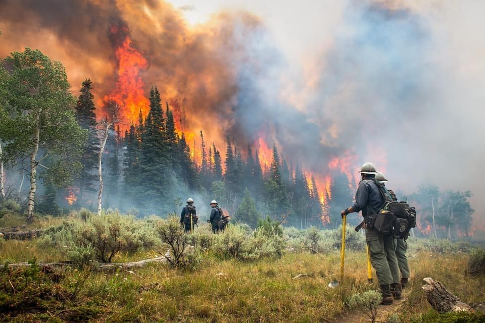
In Central Asia drylands, solar arrays boost ecosystem health
As of 2023, photovoltaic installations occupied 444 square kilometers of Central Asia, mostly in barren lands and grasslands. According to new research using satellite imagery to map these power plants’ proliferation from 2010 to 2023, the panels’ presence generally promotes plant growth, conserves soil moisture, moderates temperature swings, and reduces soil saltiness. As dryland solar power booms due to abundant sunlight and few land-use conflicts, researchers wrote, strategically siting solar arrays could help improve ecological resilience and restoration while generating clean energy at the same time. [Earth’s Future study] 

Dammed, urbanized rivers emit more planet-warming methane
Stretches of river impacted by urbanization and damming emitted 1.7 to 2.1 times more methane than less-disturbed upper reaches, according to new research of 747 kilometers of a river in northern China during late summer. Slower streamflow and sewage input in these areas cause fine sediment and nutrients to build up, oxygen to deplete, and methane-making microbes to proliferate. The result highlights the role humans play in controlling methane emissions along human-disturbed rivers, which scientists recognize as a significant source of the planet-warming gas in the atmosphere, the researchers wrote. [JGR Biogeosciences study] 

Drought drove the Amazon’s 2023 switch to a carbon source
The change was caused by thirsty vegetation taking up less carbon than normal, not by the year’s extended fire season, new research shows. [Eos research spotlight][Eos editors’ highlight][AGU Advances study] 

Boomerang earthquakes don’t need complex faults
New simulations show earthquakes can reverse direction within seconds on simple, uniform faults, suggesting back-propagating subevents are more common than previously thought. [Eos editors’ highlight][AGU Advances study]

Satellite view of the California wildfires of January 2025
Satellite observations of the southern California wildfires of 2025 reveal that almost all the burned areas were reached by fire within 24 hours, and wildfires in residential areas burned more intensely than nearby natural vegetation fires at night. [Eos editors’ highlight][AGU Advances study] 

Future hotspots of hazardous rivers in the atmosphere
Atmospheric rivers can produce heavy precipitation and associated hazards worldwide. A new study identifies regions where these hazards have already, and will further, increase with global heating. [Eos editors’ highlight][AGU Advances study] 

Subscribe or update your subscription preferences 

2/26/2026: Human actions intensify flood risk around the globe

Muddy water flooding over the banks of a river and inundating a road in a wide, flat landscape dotted with tree and shrubs, seen from the air.

Flooding of the Burke River in Queensland, Australia during Tropical Cyclone Trevor in 2019. New research projects that up to 70% of Earth’s land will face worsened flood risks as human-driven climate change continues. Credit: John Robert McPherson, Wikimedia Commons

AGU News 

AGU and global partners announce platform to advance responsible governance of solar geoengineering research
As interest in solar geoengineering research grows, a group of international scientific, policy, and civil society organizations today announced a new platform designed to bring clarity, consistency, and public accountability to how this research is governed. [press release] [Solar Geoengineering Research Governance Platform] 

Featured Research 

Human actions intensify flood risk around the globe
Under human-induced global warming of 1.5 to three degrees Celsius, 60% to 70% of Earth’s land surface will likely face rising flood risks, especially in tropical regions. The increase comes mostly in the form of larger floods, though floods also become 10% more probable, on global average, under two degrees of warming than under 1.5. Near hydrological basins, researchers said, up to 88% of the increase in risk would not occur without human-driven climate change and past water and land management. By 2065, they project, the influence of human activities on flood risk will become apparent across nearly 40% of global land area. The team came to these results using model simulations of river discharge and climate impacts, aiming to account for human land and water management more than climate models typically do. [JGR Atmospheres study] 

Minnesota winters may warm up to 12 degrees Fahrenheit this century
Winters in Minnesota may become up to 12.6 degrees Fahrenheit hotter over the course of this century, with summers warming up to 7.2 degrees. The projections draw from global climate models combined with data on the climate interactions of more than 60 of the U.S. state’s lakes. Researchers also project up to 70 and 55 fewer days per year with lake ice and snow cover, respectively, with winter snow depth thinning by over 12 centimeters and lake ice shrinking by over half on deeper lakes. Precipitation will likely fall less often — especially during mid-to-late summer, Minnesota’s peak growing season — but more intensely when it does occur. As human-driven climate change disproportionately affects high latitudes, detailed projections like these can inform decisions about agriculture, infrastructure, and water resources, the team wrote. [Water Resources Research study] 

Hydropower dries up Swedish river habitat, but strategic flow release could help
An analysis of nearly 1,000 Swedish “bypassed reaches” — river segments drained mostly dry by diversions to hydropower plants — documents over 1,250 kilometers of lost habitat where fast-flowing riffles, rapids and waterfalls once supported specialized plants and animals. Regulations guarantee some minimum flow released back into only about a quarter of these dry stretches, and in 88% of those, the amount is too low to support fish that need strong currents. Researchers found the bypassed reaches often occupy key positions in river networks, disrupting broader movements of water, nutrients, and species. Placing minimum water discharges on high-priority reaches in Sweden and beyond, they wrote, could improve ecological health and biodiversity for thousands of kilometers of river while still allowing for hydropower. [Water Resources Research study] 

Earth’s energy budget deeper in the red than forecast, even considering warming
Under global warming, more energy enters Earth’s climate system (via the sun’s rays, for instance) than leaves it, fueling a planetary energy imbalance that has climbed rapidly since 2010. Yet as of 2024, this imbalance has swelled even more than most models expect global warming to cause. Researchers realized this after teasing out the portion of the imbalance expected due to global warming from the portion driven by other factors, using satellite measurements and temperature records from Earth’s surface. The discrepancy’s exact cause remains unclear, they wrote, but the results may indicate a growing rift between modeled expectations and real-world measurements of the energy imbalance. [Geophysical Research Letters study] 

Holes drilled for carbon storage grow over time, potentially enhancing storage
An emerging strategy for mitigating climate change is to pump water containing carbon dioxide into boreholes in peridotite rocks, prompting a mineral-forming reaction that locks the planet-warming carbon away. Researchers studying two such boreholes in Oman discovered that, even over two years after drilling, four new clusters of fractures formed in the rock after heavy rainfall raised water pressure in the boreholes. The team detected the fractures using hydrophones, finding that they grew slowly downwards for over 200 meters, likely driven by water moving into them as they formed. This process could create new pathways for fluids to reach fresh rock, potentially improving the carbon storage of the system, the researchers wrote. [JGR Solid Earth study] 

New method could improve U.S. forecasting of West Nile virus
An innovative model uses regional climate data and records of West Nile virus neuroinvasive disease to outperform existing forecasts, potentially helping communities prepare. [Eos research spotlight][GeoHealth study] 

Why more rain doesn’t mean more erosion in mountains
Erosion in mountain-basin systems driven by long-period climate variations is buffered by an erosion saturation effect, which weakens peak erosion and leads to reduced sediment flux. [Eos editors’ highlight][JGR Earth Surface study] 

Subscribe or update your subscription preferences 

2/19/26: Beachgoer bacterial infections rise with Climate Change on the US East Coast

A crowd of people on a beach in Massachusetts, United States.

A crowded day at Skaket Beach in Orleans, Massachusetts, U.S. As climate change warms sea surface temperatures along the U.S. East Coast, beachgoers face worsening risk of infection by heat-loving, marine Vibrio bacteria, especially on northern coastlines. Credit: DimiTalen

AGU News 

AGU Denounces Trump Administration’s Repeal of the EPA Endangerment Finding
AGU President Brandon Jones released a statement today on the Trump Administration’s repeal of the EPA Endangerment Finding, calling it a reckless, senseless decision with global implications for human well-being and the environment. Read more:[From the Prow] 

Press registration is open for the 2026 Ocean Sciences Meeting in Glasgow, Scotland
Staff, freelance and student journalists, press officers and institutional writers are eligible to apply for complimentary press registration for the conference, which will convene 22-27 February. [media advisory][OSM26 Press][eligibility guidelines][preview conference hotels]  

Featured Research 

Climate change raises risk of bacterial disease for U.S. East Coast beachgoers
Even in a future of moderate greenhouse gas emissions, beachgoers along the U.S. Eastern Seaboard will face up to 100 times more risk of infection from marine bacteria known as Vibrio in 2100 than in 2020. Knowing the bacteria proliferate faster in warmer waters, researchers simulated risk of infection by two Vibrio species (V. vulnificus and V. parahaemolyticus) over the next 75 years, comparing warming scenarios from moderate and high emissions. Under the high-emissions scenario, risk multiplied up to 1,000 times from 2020 levels. The team projected greater danger along northern coastlines and noted that actual hazards may exceed their estimates, which accounted for Vibrio exposure from accidentally swallowing seawater but not infection through wounds. [GeoHealth study] 

India’s entire coastline is sinking, putting millions at risk
In the first assessment of land subsidence across India’s entire coast, based on satellite data from 2016 to 2024, researchers have documented ubiquitous land sinking, far more widespread than previously thought. Hotspots include several high-population cities, with Chennai and Kolkata among them. The five major deltas of India’s east coast, heavily farmed regions, are sinking up to 20 millimeters per year, while over 8.5 million people live in areas sinking more than 5 millimeters per year. Land subsidence augments the risks of sea level rise for the more than 200 million Indians living within 100 kilometers of the coast, many in low-lying, flood-prone regions. [Geophysical Research Letters study] 

Socially vulnerable Americans face worsening, disproportionate extreme heat risk
Residents of the contiguous U.S. in socially vulnerable communities, on average, weathered extreme heat nearly 3 degrees Fahrenheit hotter than their low-vulnerability counterparts between 1994 and 2023. That’s up from a 2.3-degree disparity over the period from 1951 to 1980, a recent study finds — and the gap will continue to widen as human-driven global warming continues. Using climate observations and future climate projections at fine spatial scales, researchers also found that at 2 degrees Celsius of warming, vulnerable communities will see up to 18 more days per year over 95 degrees F than non-vulnerable ones, with some areas getting more than 180 days per year over that threshold. Above 95 degrees F, using fans to cool off can worsen heat stress by blowing hot air over the body. [Earth’s Future study]

Global warming and rising seas stymie salt marshes’ carbon sequestration
The combination of human-driven global warming and saltwater intrusion from sea level rise may hinder salt marshes’ ability to sequester carbon and mitigate climate change. Researchers monitored soils from salt marshes in China’s Yangtze River estuary both in the field and under controlled levels of temperature and salinity. Temperatures over 25 degrees Celsius (77 degrees Fahrenheit) boosted the soils’ emissions of carbon dioxide and nitrous oxide, both greenhouse gases — and saltier conditions amplified the effect. This suggests that salt marshes may become less effective carbon sinks as temperatures climb and sea levels rise, the team said. [Earth’s Future study]

Children’s asthma-related hospital visits rise when wildfire smoke fills the air
Asthma-related hospital visits among children rise when wildfire smoke pollutes the air, a recent study finds. Looking at data from 2017 to 2020 from a children’s hospital serving two counties in Northern California, researchers found that an additional 10 micrograms per cubic meter of smoke particulates correlated with a 4% higher risk of hospital visits the same day and a 13% higher cumulative risk over the ensuing five days. The effect amplified in communities already facing environmental and socioeconomic stress. As wildfire smoke events to continue worsening in the Western U.S. under human-driven climate change, the team wrote, public health efforts must prioritize children in vulnerable communities during wildfires. [GeoHealth study] 

Subscribe or update your subscription preferences 

2/12/26: Climate patterns put a damper on African dust storms

A dirt road in the desert with wind kicking up dust

Wind kicks up dust on a dirt road in the Sahara Desert. Dust storms in northern Africa can negatively impact human health and agriculture, but also play a major role in forming clouds and delivering nutrients around the world. Large-scale climate phenomena are making these storms less frequent, a trend likely to continue with climate change. Credit: Armands Brants

AGU News

AGU Denounces Trump Administration’s Repeal of the EPA Endangerment Finding
AGU President Brandon Jones released a statement today on the Trump Administration’s repeal of the EPA Endangerment Finding, calling it a reckless, senseless decision with global implications for human well-being and the environment. Read more: [From the Prow]

Press registration is open for the 2026 Ocean Sciences Meeting in Glasgow, Scotland
Staff, freelance and student journalists, press officers and institutional writers are eligible to apply for complimentary press registration for the conference, which will convene 22-27 February. [media advisory][OSM26 Press][eligibility guidelines][preview conference hotels]

Featured Research

North African dust storms are in decline. Climate change may continue the trend.
Dust storms in the Sahara and Sahel regions of northern Africa have declined at a rate of roughly 0.1 storms per month since the mid-1980s. In a recent study, researchers say the major cause was the Atlantic Multidecadal Oscillation, a long-term pattern of anomalous surface temperatures in the North Atlantic Ocean. In the Sahel, this phenomenon has brought wetter, warmer conditions that moisten soil and fuel plant growth, suppressing dust, while in the Sahara, it has altered wind patterns to the same effect. The team expects the trend to continue under climate change, potentially benefiting air quality and agricultural yields in northern Africa but also impacting how much dust is in the air globally, which in turn influences cloud formation, solar radiation, and nutrient delivery. [JGR Atmospheres study]

On dry-region farms, solar panels can boost crop growth and carbon sequestration
Agrivoltaics, which sites solar panels and farm crops together, can do more than produce food and energy on the same land: in some cases, it can fight drought and enhance carbon sequestration. Researchers fed data from agrivoltaic farms in Colorado and Illinois into a computer model to simulate how the panels affected the land’s water use and carbon storage. In drier Colorado, the panels’ shade kept the soil moist, boosting grass growth and thereby storing more carbon. Amid Illinois’ wetter conditions, however, the shade mostly served to hamper maize and soybean growth, reducing carbon storage. Combining data from both sites, the researchers estimated that solar panel coverage of about 60% worked best for balancing the benefits from both solar and crops. [JAMES study]

As climate change makes floods more variable, coastal deltas will shrink
Coastal deltas and wetlands will likely shrink and sequester less carbon as the timing and intensity of extreme rains and floods get more variable, as scientists expect due to human-driven climate change. In a recent study, researchers ran two experiments on miniature-scale deltas in a lab — one with a constant flood discharge, and one with a variable flow that tripled in volume from base flow to peak flow. The variable flow made its delta slope into the water nearly twice as steeply, and shrink in area by 2.5 times, compared to the steady flow. The former delta also held 108% less organic material, suggesting variable flooding patterns could reduce wetland’s carbon sequestration abilities. [Geophysical Research Letters study]

As warming worsens hot droughts, plants contribute more to ozone pollution
Simultaneous heatwaves and drought, an increasing phenomenon in the northern hemisphere due to global warming, spur plants’ production of ozone-forming chemicals while reducing their ability to suck ozone from the air, a recent study found. Researchers used models to estimate chemical interactions between plants and the atmosphere during hot droughts, with a focus on the US, western Europe, and China. Except in cases of severe drought, the models indicated that hot drought augments plant emissions of ozone precursors by 10% to 24%, mainly due to heat boosting the activity of enzymes central to the process. Drought, meanwhile, prompts plants to close their stomata, or pores, to save water, exchanging gases with the atmosphere up to 36% less and therefore removing less ozone from the air. [JGR Atmospheres study]

Rising gases flag hidden faults in Türkiye
Leaks of carbon dioxide and radon gas from soils in Türkiye align with the presence of underground faults, potentially even revealing previously unknown fault areas, according to a recent study. Researchers measured gas emissions from soils at 98 sites in the Hatay Province of southeastern Türkiye after the country’s 2023 earthquake. In two areas, they found gas leaking along linear paths. Faults may allow gases to rise to the surface, the team wrote, meaning the measurements may indicate buried faults associated with known fault structures. The gas patterns even showed one fault may stretch farther west than previously estimated. The researchers said this confirms soil gases offer a way to detect hidden faults and improve earthquake risk assessment. [Geochemistry, Geophysics, Geosystems study]

How the spring thaw influences arsenic levels in lakes
Four lakes near Yellowknife, Canada, show that there’s no one-size-fits-all answer. [Eos research spotlight][JGR Biogeosciences study]

A road map to truly sustainable water systems in space
Future astronauts need efficient, durable, and trustworthy closed-loop systems to provide water for missions lasting months to years. [Eos research spotlight][Water Resources Research study]

Why are thunderstorms more intense over land than ocean?
A new perspective on convective instability sheds light on the factors controlling intensity in the rising motions that produce precipitation, and occasionally thunder and lightning, over land. [Eos editors’ highlight][Geophysical Research Letters study]

Subscribe or update your subscription preferences

2/5/2026: This purple flower is a carbon-storing power player

photograph of small purple flowers on brown stems against a blurry brown and green background

Flowers of Limonium narbonense, a species of sea lavender native to Mediterranean coasts. The plant’s hardy, extensive belowground structures make it adept at securely storing carbon, boosting the climate-mitigation services of the salt marshes where it often grows. Credit: Hectonichus, Wikimedia

AGU News

Press registration is open for the 2026 Ocean Sciences Meeting in Glasgow, Scotland
Staff, freelance and student journalists, press officers and institutional writers are eligible to apply for complimentary press registration for the conference, which will convene 22-27 February. [media advisory][OSM26 Press][eligibility guidelines][preview conference hotels]

Featured Research

This purple flower is a carbon-storing power player
Sea lavender, a genus of flowering plants common to coastal areas around the Mediterranean, may boost the carbon storage abilities of salt marshes. Researchers studying the distribution of biomass and carbon content in a salt marsh of Italy’s Venice Lagoon found a sea lavender species growing wherever carbon storage was highest, more so than six other common species they examined. The plant grows plenty of tough, woody mass underground that durably locks away carbon, the researchers explain, making it a valuable member of salt marsh communities. Because salt marshes trap and store carbon far more effectively than solid-land ecosystems, managing them sustainably matters for mitigating human-driven climate change. [JGR Biogeosciences study]

Arctic melting may hasten the loss of Antarctic ice, too
A domino-style series of connections and feedbacks between the poles means that Arctic ice loss may speed up Antarctic ice loss as well. Researchers used model simulations of climate and ice sheets to show that as northern ice caps diminish, the newly de-iced areas and the northern Atlantic Ocean warm up. That warmer water eventually circulates to the Southern Ocean, where it periodically washes up against the Antarctic coast and amplifies the retreat of the West Antarctic ice sheet, which scientists already consider especially vulnerable to ice loss from global warming. [Geophysical Research Letters study]

Drying of giant lakes helped awaken dormant tectonic faults
Over tens of thousands of years, declining water levels at three massive lakes helped activate nearby dormant faults on the Tibetan Plateau, according to a recent study. As the water weight lightens, the researchers say, Earth’s crust slowly rebounds upward, pushing on nearby faults and making them more prone to slippage. To quantify this process, the team studied lake shorelines for indicators of historical water levels, then used a plate tectonics model to estimate how the lightened water load would affect tectonic activity. About a fifth of fault movement near Nam Co Lake over the past 116,000 years stems from this phenomenon, they found, as does roughly 70 meters of vertical movement on the fault near the Yamzho Yumco and Puma Yumco lakes. [Geophysical Research Letters study]

Hydrogen-powered planes would leave more climate-friendly contrails
If future airplanes fly on hydrogen power, their contrails — not just their emissions — would be more climate-friendly than those of conventional kerosene-fueled planes, a recent study projects. When today’s planes fly through cold, humid air, the long, wispy contrails they leave behind can morph into clouds which act like heat-trapping “blankets” in the atmosphere, worsening the climate impact of flying. Researchers simulated how hydrogen-powered planes’ contrails would evolve over time in a range of atmospheric conditions. Contrails with fewer but larger ice crystals (as expected from hydrogen planes) faded more rapidly, partly because larger crystals drop out of the sky more quickly, reducing the overall climate impact. [JGR Atmospheres study]

Changing flight paths during space weather protects passengers from radiation
In May of 2024, a United Airlines flight from San Francisco to Paris protected those aboard from the radiation of a geomagnetic storm by altering its flight path. By comparing radiation levels recorded by onboard instruments against those estimated for a hypothetical flight that stayed on-route, researchers found that while the plane still received sporadic pulses of high radiation, the dosage would have been up to three times higher had it stayed the course. The story underscores the importance of considering alternate routes to protect passengers during space weather events like solar flares and coronal mass ejections, the team says, since Earth’s atmosphere and magnetic field provide less protection from these events’ radiation at high altitudes. [JGR Space Physics study]

Cooling crust births new subduction zones
Scientists still aren’t certain how subduction zones — boundaries where one tectonic plate slides under another — get started, partly because it’s unclear how the normally-rigid plates weaken enough to deform into such a system. In search of answers, researchers analyzed rocks from a nearly 500-million-year-old oceanic subduction zone in present-day Québec using high-resolution imaging. They found that cooling at the plate boundary altered the rocks’ mineral compositions and made grains smaller, enabling deformation — a counterintuitive result, since cooling typically strengthens rocks. While they haven’t yet pinpointed the cause of cooling, the team says this shows subduction can begin without a sudden release of built-up stress in oceanic crust. [JGR Solid Earth study]

Our oceans’ “natural antacids” act faster than we thought
New evidence from New Zealand suggests that calcium carbonate dissolution occurs not just over millennial timescales, but over annual and decadal ones too. [Eos research spotlight][AGU Advances study]

Which countries are paying the highest price for particulate air pollution?
Cutting air-polluting emissions 10% could save hundreds of thousands of lives and over a trillion dollars in the northern hemisphere each year, with the biggest benefits in China. [Eos research spotlight][GeoHealth study]

1/29/2026: Record Io eruption hints at a sponge-like interior

a glowing volcanic eruption on the surface of Io, a moon of Jupiter, as seen from space, with the eruption positioned on Io's horizon against the backdrop of space

A volcano erupts on Io, our solar system’s most volcanically active world, in an image captured in 1997 by the Galileo spacecraft. In late 2024, the Juno spacecraft witnessed Io’s most powerful known eruption, revealing clues about its subsurface structure. Credit: NASA, NASA-JPL, DLR

AGU News

Press registration is open for the 2026 Ocean Sciences Meeting in Glasgow, Scotland

Staff, freelance and student journalists, press officers and institutional writers are eligible to apply for complimentary press registration for the conference, which will convene 22-27 February. [media advisory][OSM26 Press][eligibility guidelines][preview conference hotels]

Featured Research

Io’s largest known eruption hints at a sponge-like interior
In late December of 2024, NASA’s Juno spacecraft witnessed the most intense eruption ever recorded on Io, Jupiter’s most volcanically active moon. The eruption spanned 65,000 square kilometers (over 25,000 square miles) of the southern hemisphere and released 140 to 260 terawatts of energy, over 1,000 times more than usual for the area by previous estimates. Three other hotspots also lit up enough to place them among the 10 most powerful known on Io — though other nearby volcanoes did not. Scientists interpret this as a single event affecting an underground network of massive, interconnected magma chambers, almost like pores in a giant sponge. [JGR Planets study]

Earthquakes may tease their final sizes right at the start
Just a few seconds of an earthquake’s onset hold enough information to predict its eventual size, potentially. After training a deep learning model on data from over 2,100 earthquakes showing changes in the energy they released over time, researchers found the model needed, at most, the first five seconds of data from a quake — accounting for the first 20% of the rupture process — to predict its magnitude with at least 80% accuracy. The finding could eventually inform the creation of more effective earthquake early warning systems. [JGR Machine Learning and Computation study]

To save water in the southwestern U.S., attitude change efforts alone may not suffice
Rather than rely solely on policies encouraging residents to save water, cities and towns in the southwestern U.S. should employ a diverse set of strategies to conserve water as human-driven climate change makes droughts more frequent and intense, a recent study suggests. Researchers used a computer model to simulate how policies aimed at reducing water demand affected reservoir supply in Denver, Las Vegas, and Phoenix under different climate change scenarios. While the policies counteracted the negative impacts of climate change in some cases, they proved insufficient in others. To maintain water availability under climate change, the team wrote, a multi-pronged approach may be the safest bet. [Water Resources Research study]

US faces coin-toss odds of trillion-dollar climate damages in the next five years
The U.S. has a roughly 54% chance of suffering over one trillion dollars in damages from extreme weather and climate disasters between 2026 and 2030 alone. The estimate comes from a recent statistical model using the National Oceanic and Atmospheric Administration’s database of billion-dollar climate disasters from 1980 to 2024 to extrapolate into the near future. Disasters at that level are occurring more often due to both climate change and communities’ increasing vulnerability: in the 1980 to 2024 period, even the record-high financial toll of Hurricane Katrina was not an outlier but an expected result. [Geophysical Research Letters study]

Beaufort Sea landfast ice, once thought consistent, is disappearing
An updated 27-year record of northern Alaska’s landfast sea ice — ice reaching over the sea from the coast — contradicts previous findings that the Beaufort Sea’s seasonal landfast ice has held steady since the 1970s. Instead, a comparison of the new data against 1970s satellite data shows its annual extent shrank an average of 2.5 kilometers (1.5 miles) from then to the late 1990s and aughts. The ice’s seasonal duration has also shortened at a rate of 13 days per decade from 1996 to 2023, an outcome consistent with ocean warming. The researchers say the Beaufort Sea is likely on track to lose its most extensive areas of landfast sea ice, which provide seasonal coastal erosion protection, wildlife habitat, and platforms for human hunting and travel. [JGR Oceans study]

Subscribe or update your subscription preferences