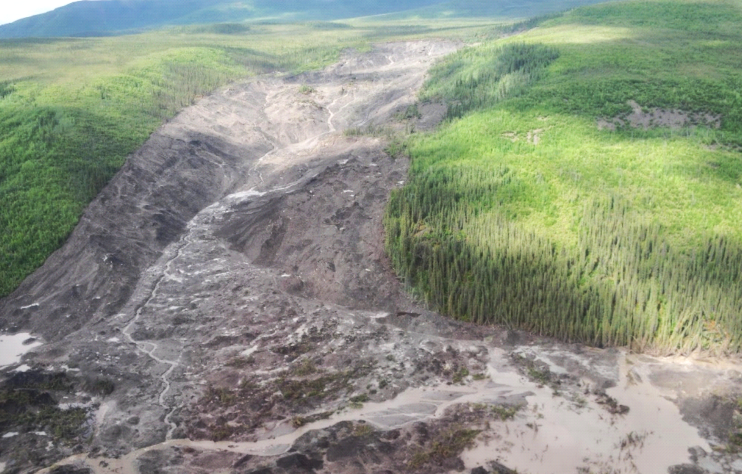
The 350-meter-wide (1150-foot-wide) scar from the 2018 Redstone River permafrost landslide in Canada’s Northwest Territories. Researchers propose that this slide was a new type of landslide where slabs of permafrost detach from underlying slopes, sending huge volumes of icy debris downhill. Credit: Adapted from Young et al. 2026 (Figure 2).
AGU News
Press registration is open for 2026 AGU Annual Meeting
Press registration is now open for AGU’s 2026 annual meeting in San Francisco, California, convening 7 to 11 December 2026 at the George R. Moscone Convention Center. Staff, freelance and student journalists are eligible to apply for complimentary press registration until the end of the conference on Friday, 11 December. Press officers and institutional writers covering the meeting are also eligible for press registration.
- REGISTER AS PRESS HERE
- Additional information for press can be found in the conference Press Center.
- Learn about press eligibility requirements.
Featured Research
Huge slabs of permafrost careen down hillsides in a new type of landslide
After two unusually large permafrost collapses in Canada’s Northwest Territories in 2017 and 2018 that left scars up to 2 miles (3.2 kilometers) long on the landscape, scientists have discovered a new type of landslide caused by tens of meters thick. Warm surface temperatures and flash-heating by wildfires kick-start small permafrost movements that create cracks in the ground, enabling water to trickle down to the base of the permafrost and melt the frozen soil from below. This weakens the connection between the permafrost and the underlying ground until the entire permafrost layer breaks free. Compared to landslides and ground slumps caused by top-down melting of permafrost, these new slides unleash much larger volumes of debris and could become more frequent as climate change exposes permafrost to more warming and wildfires. [Geophysical Research Letters study]
Marine heatwaves are reaching deeper, hurting base of marine food web
Near the equator, the hottest part of most marine heatwaves occurs tens to hundreds of meters below the waves rather than at the sea surface. A recent study of marine heatwaves from 1993 to 2020 found that these deeper heatwaves also trap roughly three times more heat energy than their surface-level counterparts. During these events, temperatures at around 100 meters’ depth typically reached about a degree Celsius hotter than normal but sometimes got up to nearly 2.5 degrees hotter. Crucially, subsurface heatwaves have also stretched deeper over time, with anomalous temperatures penetrating nearly 140 meters (over 450 feet) further in 2020 than in 1993. Both types of heatwaves hamper the growth of surface-dwelling phytoplankton, tiny ocean plants that feed the rest of the marine food web — but subsurface heatwaves also hurt the phytoplankton living at greater depths, threatening ocean life across a broader swath of the water column. [Geophysical Research Letters study]
Arctic summer sea ice on track to disappear between 2030 and 2050
Summertime Arctic sea ice shrinks by an area about the size of a full-size mattress (2.3 square meters or 25 square feet) for every ton of human CO2 emissions, according to a new study. Based on sea ice observations from 1979 to 2024 and climate simulations, researchers expect that Arctic summer sea ice will vanish entirely once cumulative human CO2 emissions hit around 3,500 billion tonnes (3,860 billion U.S. tons). With 2,700 billion tonnes (2,980 billion U.S. tons) already in the atmosphere as of the end of 2025, moderate- emissions scenarios project we will cross this ice-free threshold sometime between 2030 and 2050. [Geophysical Research Letters study]
Urban boundaries in protected forests are hotspots for forest loss — and gain
Human activities increasingly encroach into areas protected for conservation all over the world, bringing landscape changes, pollution, and invasive species that threaten the effectiveness of protected areas for preserving carbon stores and biodiversity. Between 2000 and 2023, more than half of global forest loss in protected areas occurred due to human activity within 5 kilometers (3 miles) of a boundary between developed and undeveloped land, according to a new study. These same boundary areas also contributed to half of all reforestation between 2000 and 2020, but this only amounts to 21,000 square miles of new forest versus 110,000 square miles of deforestation. Most losses owe to agriculture and logging in temperate and tropical forests, regions that researchers suggest also have the greatest potential for reforestation. [Earth’s Future study]
Commentary calls for collective bargaining to maintain ethics in Earth science consulting
A new commentary presents a case study in which junior environmental consultants evaluating flood risk for a nuclear plant faced pressure from supervisors to avoid recommending costly flood-proofing retrofits. Their final recommendation, the authors wrote, traded scientific rigor and potentially public safety for the client’s preferred outcome. The authors could help geoscientists resist pressure to compromise their science, which would particularly benefit the junior workforce. They also call on senior scientists to emphasize ethics as they train the next generation of geoscientists. [Earth’s Future commentary]
The Ocean Circulation That Persists Even After a Key AMOC Component Fails
A new study suggests cross-hemispheric overturning circulation could continue for centuries, even as North Atlantic Deep Water formation shuts down. [Eos Research Spotlight] [AGU Advances study]